
- Start >
- Rivers >
- Waterlevel >
- Bayern >
- Türkheim >
- Chart of year

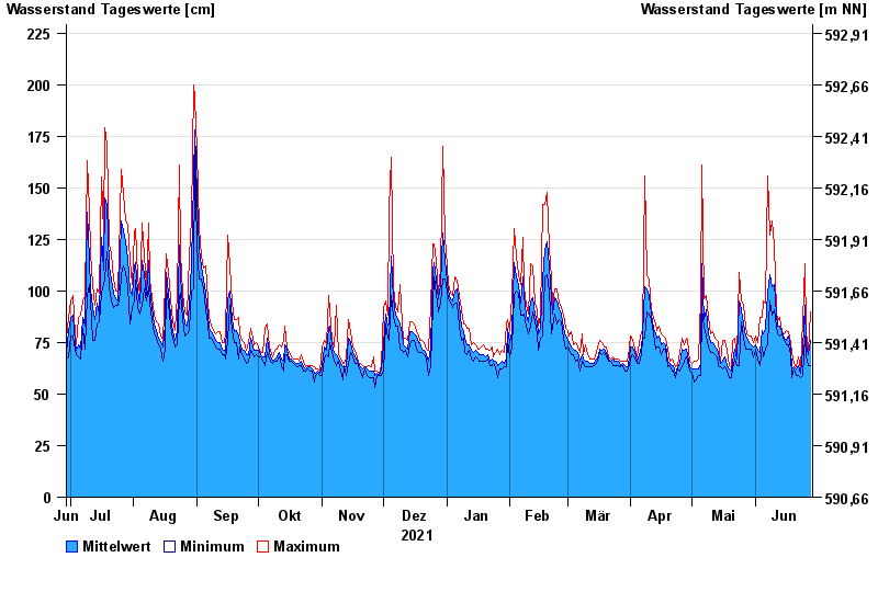
Chart of year Türkheim / Wertach
Waterlevel from 29.06.2021 to 28.06.2022
note
Beeinflussung durch Kraftwerksbetrieb
- 02.06.1906 Wasserstand: 503 cm
- 16.06.1910 Wasserstand: 500 cm
- 26.07.1906 Wasserstand: 495 cm
- 06.04.1901 Wasserstand: 480 cm
- 31.05.1940 Wasserstand: 479 cm
| Date | Mean value [cm] | Maximum [cm] | Minimum [cm] |
|---|---|---|---|
| 28.06.2022 | 76 | 90 | 64 |
| 27.06.2022 | 69 | 70 | 64 |
| 26.06.2022 | 74 | 80 | 68 |
| 25.06.2022 | 93 | 113 | 78 |
| 24.06.2022 | 72 | 86 | 59 |
| 23.06.2022 | 60 | 62 | 58 |
| 22.06.2022 | 64 | 68 | 59 |
© Bayerisches Landesamt für Umwelt 2025