
- Start >
- Rivers >
- Waterlevel >
- Bayern >
- Schönbrunn >
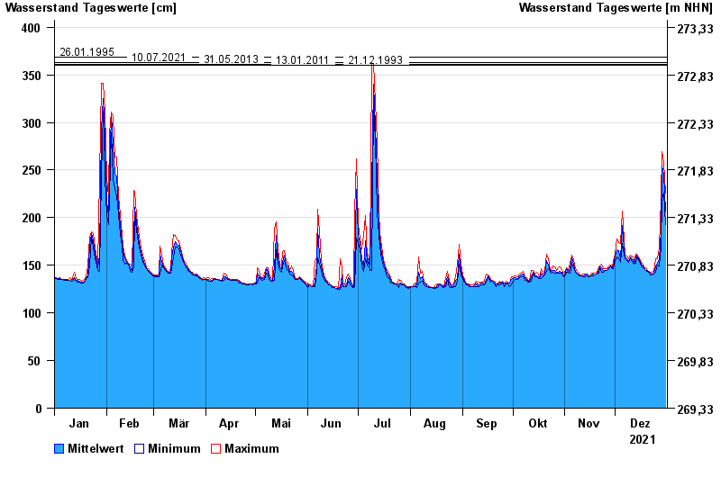
- Chart of year

Chart of year Schönbrunn / Rauhe Ebrach
Waterlevel from 01.01.2021 to 31.12.2021
note
Beeinflussung des Abflusses aufgrund Hindernisse im Unterlauf
- 26.01.1995 Wasserstand: 369 cm
- 10.07.2021 Wasserstand: 363 cm
- 31.05.2013 Wasserstand: 361 cm
- 13.01.2011 Wasserstand: 360 cm
- 21.12.1993 Wasserstand: 360 cm
| Date | Mean value [cm] | Maximum [cm] | Minimum [cm] |
|---|---|---|---|
| 31.12.2021 | 207 | 226 | 193 |
| 30.12.2021 | 246 | 258 | 226 |
| 29.12.2021 | 254 | 269 | 220 |
| 28.12.2021 | 186 | 220 | 169 |
| 27.12.2021 | 156 | 169 | 149 |
| 26.12.2021 | 153 | 157 | 150 |
| 25.12.2021 | 148 | 157 | 143 |
© Bayerisches Landesamt für Umwelt 2024