
- Start >
- Rivers >
- Waterlevel >
- Bayern >
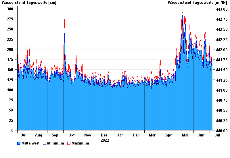
- Rosenheim u.d. Mangfallmündung >
- Chart of year

Chart of year Rosenheim u.d. Mangfallmündung / Inn
Waterlevel from 07.07.2022 to 06.07.2023
- 23.08.2005 Wasserstand: 511 cm
- 07.08.1985 Wasserstand: 483 cm
- 02.06.2013 Wasserstand: 468 cm
- 21.05.1999 Wasserstand: 451 cm
- 20.07.1981 Wasserstand: 441 cm
| Date | Mean value [cm] | Maximum [cm] | Minimum [cm] |
|---|---|---|---|
| 06.07.2023 | 178 | 186 | 168 |
| 05.07.2023 | 178 | 184 | 168 |
| 04.07.2023 | 164 | 168 | 157 |
| 03.07.2023 | 157 | 165 | 152 |
| 02.07.2023 | 158 | 173 | 147 |
| 01.07.2023 | 199 | 216 | 173 |
| 30.06.2023 | 173 | 185 | 159 |
© Bayerisches Landesamt für Umwelt 2024