
- Start >
- Rivers >
- Waterlevel >
- Bayern >
- Iglersreuth Speicherzufluss >
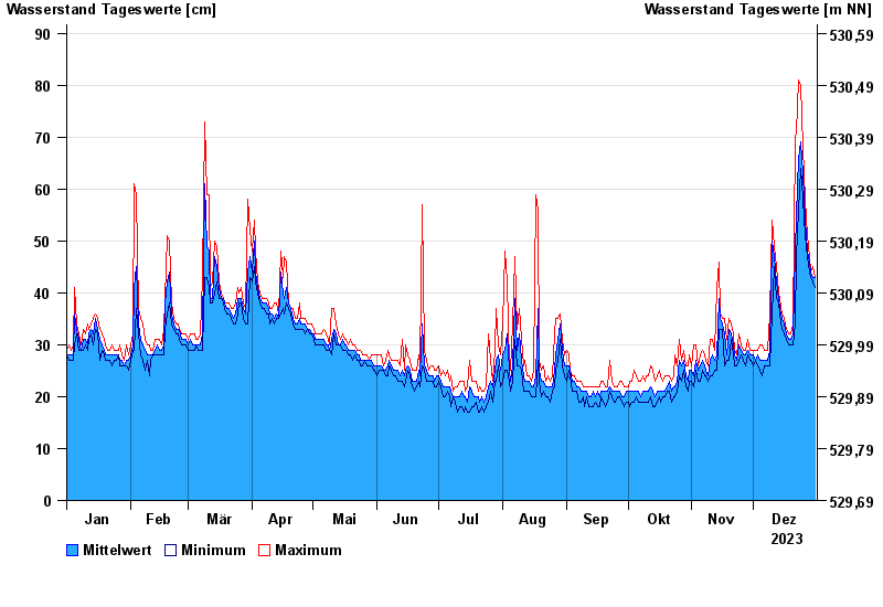
- Chart of year

Chart of year Iglersreuth Speicherzufluss / Tirschenreuther Waldnaab
Waterlevel from 01.01.2023 to 31.12.2023
- 10.08.1984 Wasserstand: 162 cm
- 05.05.1984 Wasserstand: 155 cm
- 06.06.1984 Wasserstand: 130 cm
- 12.02.2005 Wasserstand: 124 cm
- 02.01.2003 Wasserstand: 112 cm
| Date | Mean value [cm] | Maximum [cm] | Minimum [cm] |
|---|---|---|---|
| 31.12.2023 | 43 | 43 | 41 |
| 30.12.2023 | 43 | 45 | 42 |
| 29.12.2023 | 44 | 44 | 43 |
| 28.12.2023 | 46 | 47 | 44 |
| 27.12.2023 | 48 | 51 | 47 |
| 26.12.2023 | 54 | 58 | 51 |
| 25.12.2023 | 63 | 68 | 58 |
© Bayerisches Landesamt für Umwelt 2024