
- Start >
- Groundwater >
- Waterlevel of upper layer >
- Untere Donau >
- WALCHSING >
- Chart of total period

Chart of total period WALCHSING
Groundwater levels of the total period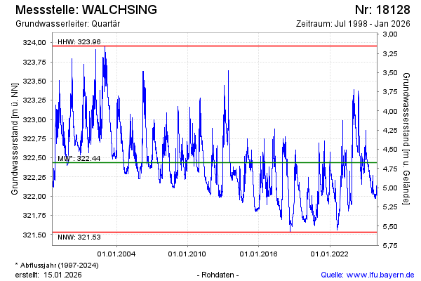
note
GW Messstelle im Grundnetz
Groundwater level [m above sealevel]: 321.94
Distance to surface [m]: 5.17
Last value from 29.05.2026 04:00
Ground level [m above sealevel]: 327.11
| Date | Groundwater level [m above sealevel] |
|---|---|
| 28.05.2026 | 321.94 |
| 27.05.2026 | 321.95 |
| 26.05.2026 | 321.96 |
| 25.05.2026 | 321.97 |
| 24.05.2026 | 321.98 |
| 23.05.2026 | 321.98 |
| 22.05.2026 | 321.99 |
| 21.05.2026 | 322.00 |
© Bayerisches Landesamt für Umwelt 2026