
- Start >
- Groundwater >
- Waterlevel of upper layer >
- Bayern >
- SIMBACH B 4A >
- Chart of total period

Chart of total period SIMBACH B 4A
Groundwater levels of the total period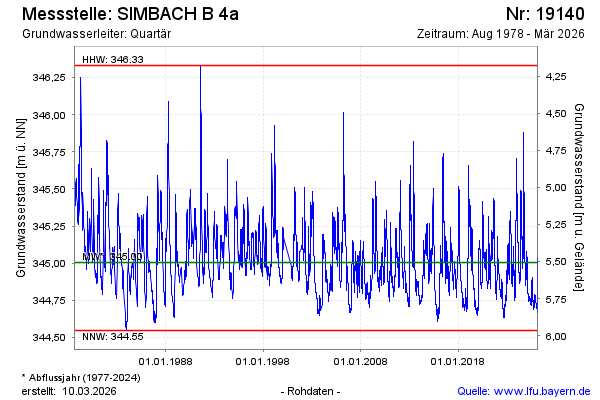
note
GW Messstelle im Grundnetz
Groundwater level [m above sealevel]: 344.84
Distance to surface [m]: 5.67
Last value from 15.04.2026 08:00
Ground level [m above sealevel]: 350.51
| Date | Groundwater level [m above sealevel] |
|---|---|
| 15.04.2026 | 344.84 |
| 14.04.2026 | 344.84 |
| 13.04.2026 | 344.85 |
| 12.04.2026 | 344.85 |
| 11.04.2026 | 344.86 |
| 10.04.2026 | 344.86 |
| 09.04.2026 | 344.86 |
| 08.04.2026 | 344.87 |
© Bayerisches Landesamt für Umwelt 2026