
- Start >
- Groundwater >
- Waterlevel of upper layer >
- Bayern >
- Hammer Gw2 (BK4) >
- Chart of total period

Chart of total period Hammer Gw2 (BK4)
Groundwater levels of the total period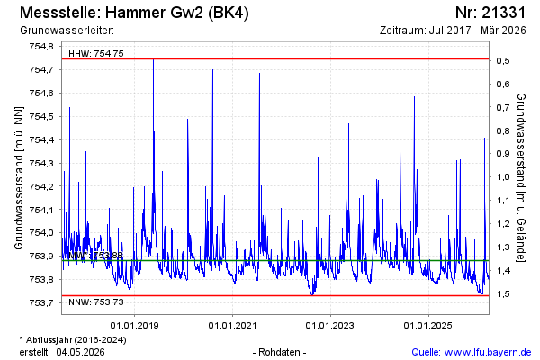
Groundwater level [m above sealevel]: 753.82
Distance to surface [m]: 1.42
Last value from 30.03.2026 11:07
Ground level [m above sealevel]: 755.24
| Date | Groundwater level [m above sealevel] |
|---|---|
| 30.03.2026 | 753.81 |
| 29.03.2026 | 753.81 |
| 28.03.2026 | 753.80 |
| 27.03.2026 | 753.80 |
| 26.03.2026 | 753.81 |
| 25.03.2026 | 753.80 |
| 24.03.2026 | 753.80 |
| 23.03.2026 | 753.80 |
© Bayerisches Landesamt für Umwelt 2026