
- Start >
- Groundwater >
- Waterlevel of upper layer >
- Bayern >
- Flussraummanagement Vils, MQS 03-L (ML03) >
- Current data

Current data Flussraummanagement Vils, MQS 03-L (ML03)
Groundwater levels of the last 12 months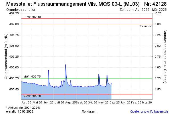
Groundwater level [m above sealevel]: 405.70
Distance to surface [m]: 1.30
Last value from 08.12.2025 10:25
Ground level [m above sealevel]: 407.00
| Date | Groundwater level [m above sealevel] |
|---|---|
| 08.12.2025 | 405.65 |
| 07.12.2025 | 405.58 |
| 06.12.2025 | 405.59 |
| 05.12.2025 | 405.59 |
| 04.12.2025 | 405.60 |
| 03.12.2025 | 405.61 |
| 02.12.2025 | 405.61 |
| 01.12.2025 | 405.61 |
© Bayerisches Landesamt für Umwelt 2026