
- Start >
- Groundwater >
- Waterlevel of upper layer >
- Bayern >
- Endinger Loch >
- Chart of total period

Chart of total period Endinger Loch
Groundwater levels of the total period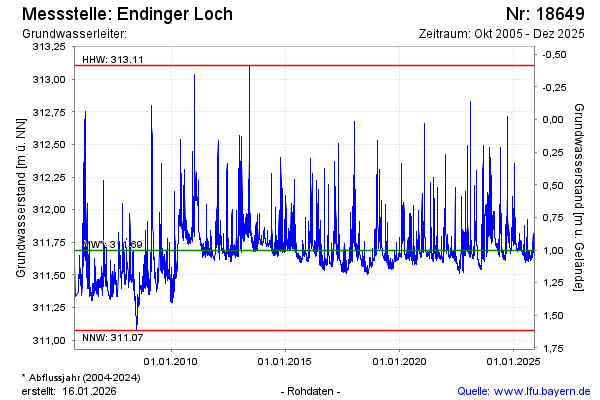
note
GW Messtelle im SN Flussraum Vils
Groundwater level [m above sealevel]: 311.64
Distance to surface [m]: 1.05
Last value from 25.04.2026 09:30
Ground level [m above sealevel]: 312.69
| Date | Groundwater level [m above sealevel] |
|---|---|
| 15.04.2026 | 311.64 |
| 14.04.2026 | 311.65 |
| 13.04.2026 | 311.66 |
| 12.04.2026 | 311.66 |
| 11.04.2026 | 311.66 |
| 10.04.2026 | 311.65 |
| 09.04.2026 | 311.63 |
| 08.04.2026 | 311.63 |
© Bayerisches Landesamt für Umwelt 2026