
- Start >
- Groundwater >
- Waterlevel of upper layer >
- Bayern >
- BETLINSH./ILLERTISS.K >
- Chart of total period

Chart of total period BETLINSH./ILLERTISS.K
Groundwater levels of the total period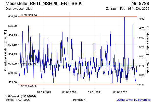
Groundwater level [m above sealevel]: 503.86
Distance to surface [m]: 5.83
Last value from 16.04.2024 10:20
Ground level [m above sealevel]: 509.69
| Date | Groundwater level [m above sealevel] |
|---|---|
| 16.04.2024 | 503.86 |
| 15.04.2024 | 503.86 |
| 14.04.2024 | 503.85 |
| 13.04.2024 | 503.86 |
| 12.04.2024 | 503.86 |
| 11.04.2024 | 503.87 |
| 10.04.2024 | 503.88 |
| 09.04.2024 | 503.88 |
© Bayerisches Landesamt für Umwelt 2024