
- Start >
- Groundwater >
- Waterlevel of deep layer >
- Bayern >
- FISCHERHÄUSER T2A >
- Chart of total period

Chart of total period FISCHERHÄUSER T2A
Groundwater levels of the total period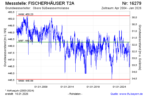
Groundwater level [m above sealevel]: 446.34
Distance to surface [m]: 33.76
Last value from 08.05.2026 10:00
Ground level [m above sealevel]: 480.10
| Date | Groundwater level [m above sealevel] |
|---|---|
| 08.05.2026 | 446.57 |
| 07.05.2026 | 446.51 |
| 06.05.2026 | 446.50 |
| 05.05.2026 | 446.50 |
| 04.05.2026 | 446.50 |
| 03.05.2026 | 446.55 |
| 02.05.2026 | 446.40 |
| 01.05.2026 | 446.41 |
© Bayerisches Landesamt für Umwelt 2026