
- Start >
- Groundwater >
- Waterlevel of deep layer >
- Bayern >
- BRUNNEN I FÜRSTBERG >
- Chart of total period

Chart of total period BRUNNEN I FÜRSTBERG
Groundwater levels of the total period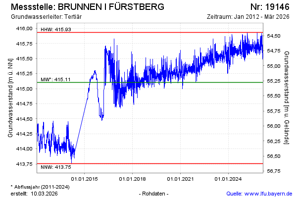
Groundwater level [m above sealevel]: 415.50
Distance to surface [m]: 54.88
Last value from 09.05.2024 08:00
Ground level [m above sealevel]: 470.38
| Date | Groundwater level [m above sealevel] |
|---|---|
| 09.05.2024 | 415.51 |
| 08.05.2024 | 415.55 |
| 07.05.2024 | 415.62 |
| 06.05.2024 | 415.67 |
| 05.05.2024 | 415.64 |
| 04.05.2024 | 415.60 |
| 03.05.2024 | 415.64 |
| 02.05.2024 | 415.74 |
© Bayerisches Landesamt für Umwelt 2024