
- Start >
- Groundwater >
- Waterlevel of deep layer >
- Bayern >
- ALTDORF TIEFBOHRUNG >
- Chart of total period

Chart of total period ALTDORF TIEFBOHRUNG
Groundwater levels of the total period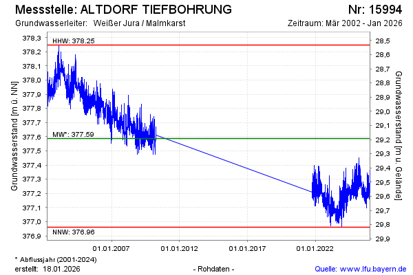
note
Keine Beobachtung von 04/2010 bis 09/2021
Groundwater level [m above sealevel]: 377.20
Distance to surface [m]: 29.58
Last value from 25.07.2024 10:00
Ground level [m above sealevel]: 406.78
| Date | Groundwater level [m above sealevel] |
|---|---|
| 24.07.2024 | 377.19 |
| 23.07.2024 | 377.18 |
| 22.07.2024 | 377.20 |
| 21.07.2024 | 377.24 |
| 20.07.2024 | 377.23 |
| 19.07.2024 | 377.19 |
| 18.07.2024 | 377.17 |
| 17.07.2024 | 377.18 |
© Bayerisches Landesamt für Umwelt 2024