
- Start >
- Rivers >
- Waterlevel >
- Untere Donau >
- Kothmaißling >
- Chart of year

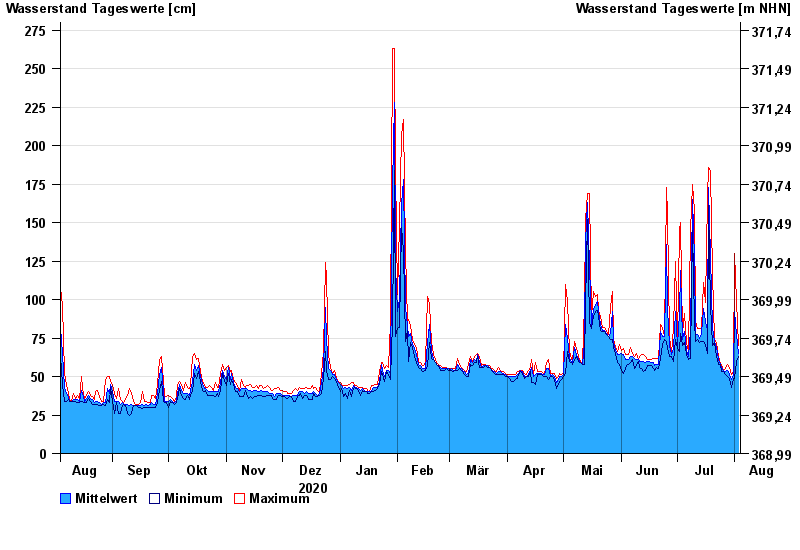
Chart of year Kothmaißling / Chamb
Waterlevel from 04.08.2020 to 03.08.2021
note
Beeinflussung durch Buhneneinbau unterhalb vom Pegel
- 13.08.2002 Wasserstand: 364 cm
- 30.12.1986 Wasserstand: 341 cm
- 23.02.1970 Wasserstand: 338 cm
- 21.12.1993 Wasserstand: 332 cm
- 05.12.1988 Wasserstand: 329 cm
| Date | Mean value [cm] | Maximum [cm] | Minimum [cm] |
|---|---|---|---|
| 03.08.2021 | 65 | 70 | 63 |
| 02.08.2021 | 77 | 99 | 60 |
| 01.08.2021 | 92 | 130 | 49 |
| 31.07.2021 | 51 | 53 | 49 |
| 30.07.2021 | 48 | 51 | 43 |
| 29.07.2021 | 51 | 56 | 49 |
| 28.07.2021 | 54 | 58 | 50 |
© Bayerisches Landesamt für Umwelt 2024