
- Start >
- Rivers >
- Waterlevel >
- Untere Donau >
- Grafentraubach >
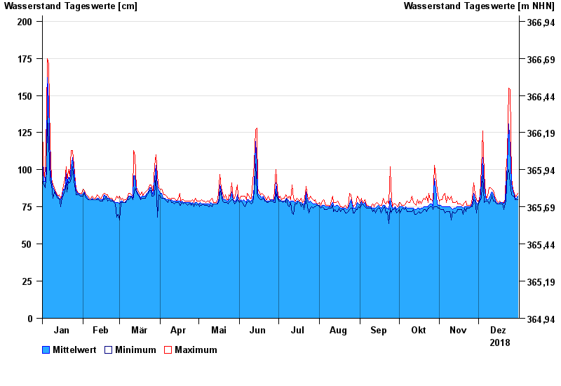
- Chart of year

Chart of year Grafentraubach / Kleine Laber
Waterlevel from 01.01.2018 to 31.12.2018
Pegel
Nahegelegene Bauarbeiten können zu Beeinflussungen des Wasserstands führen.
- 13.04.1994 Wasserstand: 246 cm
- 03.03.1987 Wasserstand: 236 cm
- 13.01.2011 Wasserstand: 234 cm
- 13.01.1982 Wasserstand: 215 cm
- 03.06.2013 Wasserstand: 211 cm
| Date | Mean value [cm] | Maximum [cm] | Minimum [cm] |
|---|---|---|---|
| 31.12.2018 | 82 | 84 | 80 |
| 30.12.2018 | 81 | 82 | 80 |
| 29.12.2018 | 81 | 82 | 80 |
| 28.12.2018 | 83 | 84 | 82 |
| 27.12.2018 | 85 | 87 | 82 |
| 26.12.2018 | 91 | 94 | 83 |
| 25.12.2018 | 115 | 154 | 91 |
© Bayerisches Landesamt für Umwelt 2024