
- Start >
- Rivers >
- Waterlevel >
- Naab - Regen >
- Trausnitz u. d. Mühle >
- Chart of year

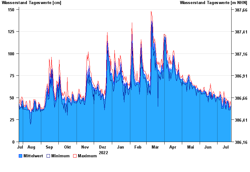
Chart of year Trausnitz u. d. Mühle / Pfreimd
Waterlevel from 25.07.2022 to 24.07.2023
- 26.01.1995 Wasserstand: 259 cm
- 03.01.2003 Wasserstand: 252 cm
- 27.03.1988 Wasserstand: 252 cm
- 22.12.1993 Wasserstand: 236 cm
- 14.01.2011 Wasserstand: 234 cm
| Date | Mean value [cm] | Maximum [cm] | Minimum [cm] |
|---|---|---|---|
| 24.07.2023 | 41 | 42 | 40 |
| 23.07.2023 | 39 | 46 | 36 |
| 22.07.2023 | 38 | 39 | 36 |
| 21.07.2023 | 38 | 39 | 36 |
| 20.07.2023 | 43 | 46 | 36 |
| 19.07.2023 | 46 | 47 | 45 |
| 18.07.2023 | 46 | 46 | 45 |
© Bayerisches Landesamt für Umwelt 2024