
- Start >
- Rivers >
- Waterlevel >
- Naab - Regen >
- Trausnitz u. d. Mühle >
- Chart of year

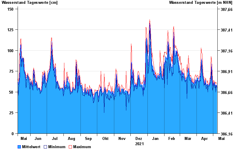
Chart of year Trausnitz u. d. Mühle / Pfreimd
Waterlevel from 09.05.2021 to 08.05.2022
- 26.01.1995 Wasserstand: 259 cm
- 03.01.2003 Wasserstand: 252 cm
- 27.03.1988 Wasserstand: 252 cm
- 22.12.1993 Wasserstand: 236 cm
- 14.01.2011 Wasserstand: 234 cm
| Date | Mean value [cm] | Maximum [cm] | Minimum [cm] |
|---|---|---|---|
| 08.05.2022 | 57 | 60 | 55 |
| 07.05.2022 | 59 | 61 | 58 |
| 06.05.2022 | 57 | 62 | 50 |
| 05.05.2022 | 59 | 60 | 57 |
| 04.05.2022 | 58 | 62 | 55 |
| 03.05.2022 | 62 | 62 | 61 |
| 02.05.2022 | 61 | 64 | 57 |
© Bayerisches Landesamt für Umwelt 2024