
- Start >
- Rivers >
- Waterlevel >
- Unterer Main >
- Schlimpfhof >
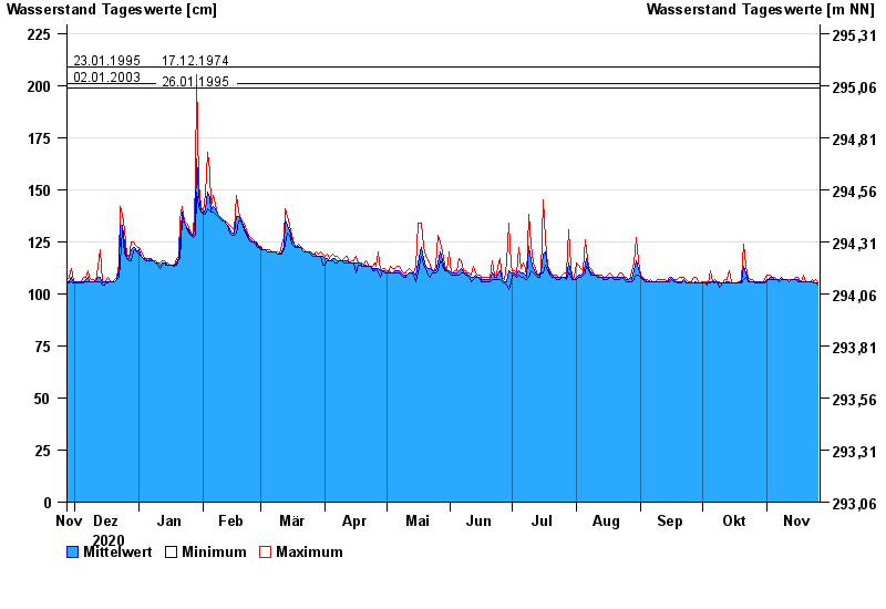
- Chart of year

Chart of year Schlimpfhof / Lauter
Waterlevel from 27.11.2020 to 26.11.2021
note
Pegel wird wegen Straßenbauarbeiten versetzt. Dauer der Maßnahme bis Ende 2023.
- 07.02.1984 Wasserstand: 232 cm
- 23.01.1995 Wasserstand: 209 cm
- 17.12.1974 Wasserstand: 209 cm
- 02.01.2003 Wasserstand: 201 cm
- 26.01.1995 Wasserstand: 199 cm
| Date | Mean value [cm] | Maximum [cm] | Minimum [cm] |
|---|---|---|---|
| 26.11.2021 | 105 | 106 | 104 |
| 25.11.2021 | 105 | 107 | 105 |
| 24.11.2021 | 105 | 106 | 105 |
| 23.11.2021 | 106 | 107 | 106 |
| 22.11.2021 | 106 | 106 | 106 |
| 21.11.2021 | 106 | 106 | 106 |
| 20.11.2021 | 106 | 106 | 106 |
© Bayerisches Landesamt für Umwelt 2024