
- Start >
- Rivers >
- Waterlevel >
- Unterer Main >
- Schlimpfhof >
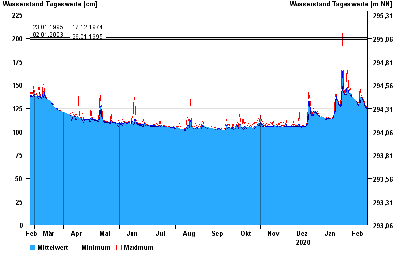
- Chart of year

Chart of year Schlimpfhof / Lauter
Waterlevel from 25.02.2020 to 24.02.2021
note
Pegel wird wegen Straßenbauarbeiten versetzt. Dauer der Maßnahme bis Ende 2023.
- 07.02.1984 Wasserstand: 232 cm
- 23.01.1995 Wasserstand: 209 cm
- 17.12.1974 Wasserstand: 209 cm
- 02.01.2003 Wasserstand: 201 cm
- 26.01.1995 Wasserstand: 199 cm
| Date | Mean value [cm] | Maximum [cm] | Minimum [cm] |
|---|---|---|---|
| 24.02.2021 | 126 | 127 | 125 |
| 23.02.2021 | 127 | 128 | 126 |
| 22.02.2021 | 129 | 131 | 128 |
| 21.02.2021 | 132 | 134 | 131 |
| 20.02.2021 | 134 | 135 | 134 |
| 19.02.2021 | 136 | 137 | 135 |
| 18.02.2021 | 137 | 140 | 135 |
© Bayerisches Landesamt für Umwelt 2024