
- Start >
- Rivers >
- Waterlevel >
- Unterer Main >
- Bad Kissingen Golfplatz >
- Chart of year

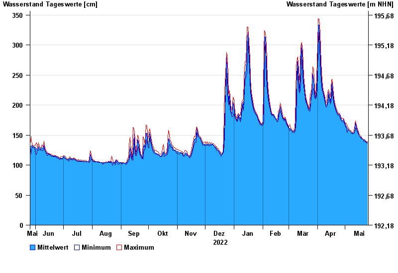
Chart of year Bad Kissingen Golfplatz / Fränkische Saale
Waterlevel from 26.05.2022 to 25.05.2023
- 03.01.2003 Wasserstand: 556 cm
- 14.01.2011 Wasserstand: 509 cm
- 23.02.1970 Wasserstand: 503 cm
- 23.01.1995 Wasserstand: 499 cm
- 07.02.1984 Wasserstand: 492 cm
| Date | Mean value [cm] | Maximum [cm] | Minimum [cm] |
|---|---|---|---|
| 25.05.2023 | 138 | 139 | 136 |
| 24.05.2023 | 138 | 140 | 138 |
| 23.05.2023 | 140 | 140 | 138 |
| 22.05.2023 | 141 | 142 | 140 |
| 21.05.2023 | 142 | 142 | 140 |
| 20.05.2023 | 142 | 144 | 142 |
| 19.05.2023 | 145 | 145 | 144 |
© Bayerisches Landesamt für Umwelt 2024