
- Start >
- Rivers >
- Waterlevel >
- Unterer Main >
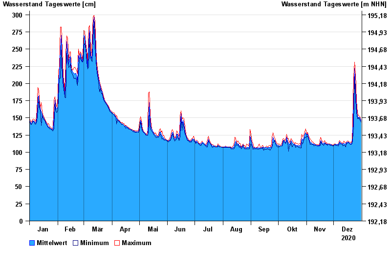
- Bad Kissingen Golfplatz >
- Chart of year

Chart of year Bad Kissingen Golfplatz / Fränkische Saale
Waterlevel from 01.01.2020 to 31.12.2020
- 03.01.2003 Wasserstand: 556 cm
- 14.01.2011 Wasserstand: 509 cm
- 23.02.1970 Wasserstand: 503 cm
- 23.01.1995 Wasserstand: 499 cm
- 07.02.1984 Wasserstand: 492 cm
| Date | Mean value [cm] | Maximum [cm] | Minimum [cm] |
|---|---|---|---|
| 31.12.2020 | 146 | 147 | 144 |
| 30.12.2020 | 150 | 152 | 147 |
| 29.12.2020 | 151 | 153 | 150 |
| 28.12.2020 | 151 | 153 | 149 |
| 27.12.2020 | 152 | 157 | 149 |
| 26.12.2020 | 165 | 175 | 157 |
| 25.12.2020 | 192 | 214 | 175 |
© Bayerisches Landesamt für Umwelt 2024