
- Start >
- Rivers >
- Waterlevel >
- Unterer Main >
- Bad Kissingen Golfplatz >
- Chart of total period

Chart of total period Bad Kissingen Golfplatz / Fränkische Saale
Waterlevel from 28.10.1963 to 26.04.2024
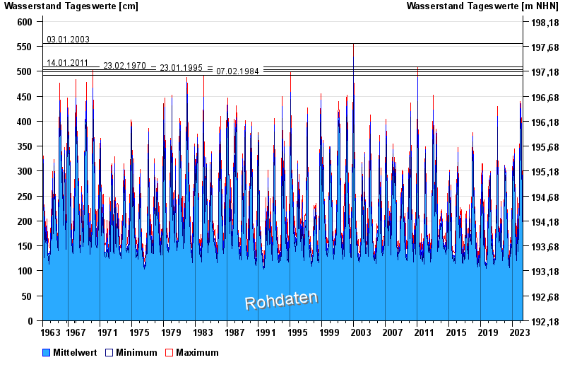
- 03.01.2003 Wasserstand: 556 cm
- 14.01.2011 Wasserstand: 509 cm
- 23.02.1970 Wasserstand: 503 cm
- 23.01.1995 Wasserstand: 499 cm
- 07.02.1984 Wasserstand: 492 cm
| Date | Mean value [cm] | Maximum [cm] | Minimum [cm] |
|---|---|---|---|
| 26.04.2024 | 178 | 180 | 178 |
| 25.04.2024 | 180 | 182 | 178 |
| 24.04.2024 | 183 | 186 | 181 |
| 23.04.2024 | 191 | 196 | 185 |
| 22.04.2024 | 207 | 218 | 195 |
| 21.04.2024 | 205 | 218 | 190 |
| 20.04.2024 | 199 | 202 | 190 |
© Bayerisches Landesamt für Umwelt 2024