
- Start >
- Rivers >
- Waterlevel >
- Isar >
- Rosenheim o.d. Mangfallmündung >
- Chart of year

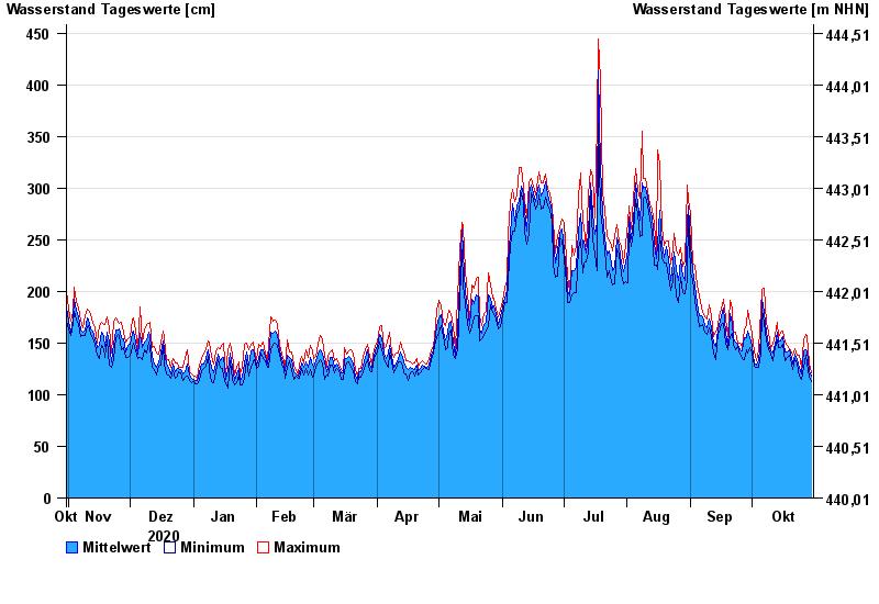
Chart of year Rosenheim o.d. Mangfallmündung / Inn
Waterlevel from 31.10.2020 to 30.10.2021
- 23.08.2005 Wasserstand: 568 cm
- 07.08.1985 Wasserstand: 551 cm
- 21.05.1999 Wasserstand: 522 cm
- 02.06.2013 Wasserstand: 511 cm
- 20.07.1981 Wasserstand: 493 cm
| Date | Mean value [cm] | Maximum [cm] | Minimum [cm] |
|---|---|---|---|
| 30.10.2021 | 118 | 121 | 113 |
| 29.10.2021 | 123 | 131 | 117 |
| 28.10.2021 | 142 | 157 | 131 |
| 27.10.2021 | 144 | 158 | 138 |
| 26.10.2021 | 142 | 153 | 126 |
| 25.10.2021 | 120 | 126 | 115 |
| 24.10.2021 | 126 | 138 | 118 |
© Bayerisches Landesamt für Umwelt 2024