
- Start >
- Rivers >
- Waterlevel >
- Isar >
- Geisenfeld >
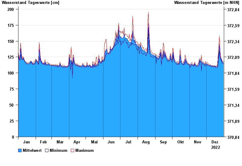
- Chart of year

Chart of year Geisenfeld / Ilm
Waterlevel from 01.01.2022 to 31.12.2022
Abflussermittlung
Die Abflussermittlung wird durch den saisonalen Pflanzenbewuchs im Gewässer beeinträchtigt.
- 13.04.1994 Wasserstand: 373 cm
- 03.06.2013 Wasserstand: 335 cm
- 15.02.1990 Wasserstand: 306 cm
- 10.03.2006 Wasserstand: 291 cm
- 02.06.1995 Wasserstand: 290 cm
| Date | Mean value [cm] | Maximum [cm] | Minimum [cm] |
|---|---|---|---|
| 31.12.2022 | 116 | 118 | 115 |
| 30.12.2022 | 117 | 118 | 115 |
| 29.12.2022 | 117 | 118 | 115 |
| 28.12.2022 | 118 | 120 | 117 |
| 27.12.2022 | 122 | 124 | 120 |
| 26.12.2022 | 122 | 124 | 120 |
| 25.12.2022 | 127 | 134 | 123 |
© Bayerisches Landesamt für Umwelt 2024