
- Start >
- Rivers >
- Waterlevel >
- Isar >
- Dürrach >
- Chart of year

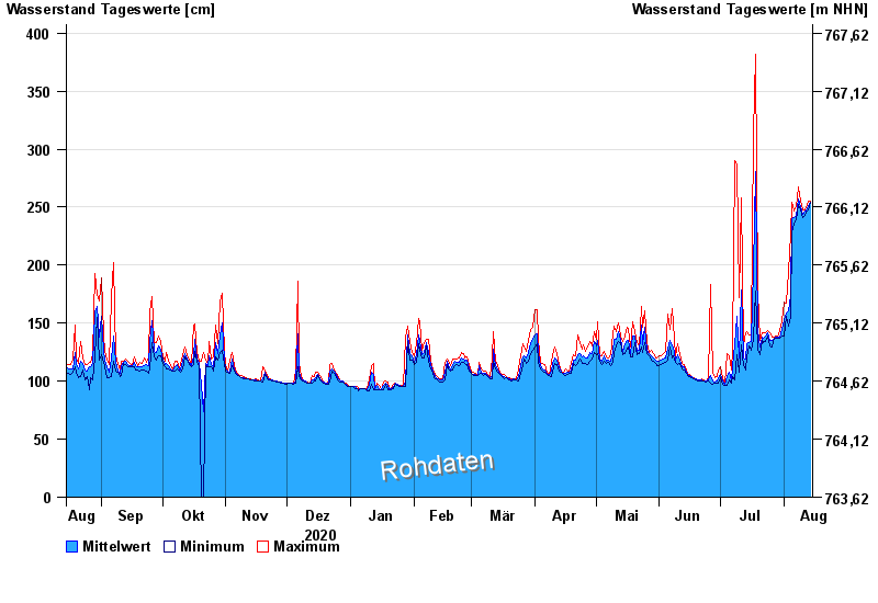
Chart of year Dürrach / Dürrach
Waterlevel from 15.08.2020 to 14.08.2021
Beeinflussung
Wasserstand durch starke Aufkiesung beeinflusst, der Abfluss ist ungültig
- 01.08.1977 Wasserstand: 599 cm
- 23.08.2005 Wasserstand: 487 cm
- 22.05.1999 Wasserstand: 459 cm
- 01.08.1992 Wasserstand: 422 cm
- 03.06.2010 Wasserstand: 420 cm
| Date | Mean value [cm] | Maximum [cm] | Minimum [cm] |
|---|---|---|---|
| 14.08.2021 | 254 | 255 | 254 |
| 13.08.2021 | 251 | 255 | 248 |
| 12.08.2021 | 247 | 249 | 246 |
| 11.08.2021 | 247 | 248 | 243 |
| 10.08.2021 | 244 | 248 | 241 |
| 09.08.2021 | 250 | 255 | 248 |
| 08.08.2021 | 257 | 267 | 252 |
© Bayerisches Landesamt für Umwelt 2024