
- Start >
- Rivers >
- Waterlevel >
- Isar >
- Dürrach >
- Chart of year

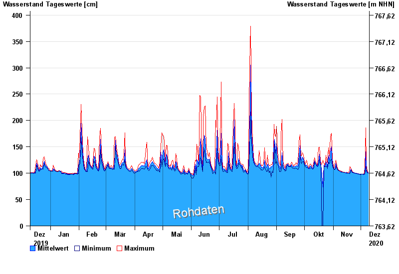
Chart of year Dürrach / Dürrach
Waterlevel from 10.12.2019 to 09.12.2020
Beeinflussung
Wasserstand durch starke Aufkiesung beeinflusst, der Abfluss ist ungültig
- 01.08.1977 Wasserstand: 599 cm
- 23.08.2005 Wasserstand: 487 cm
- 22.05.1999 Wasserstand: 459 cm
- 01.08.1992 Wasserstand: 422 cm
- 03.06.2010 Wasserstand: 420 cm
| Date | Mean value [cm] | Maximum [cm] | Minimum [cm] |
|---|---|---|---|
| 09.12.2020 | 101 | 101 | 100 |
| 08.12.2020 | 102 | 104 | 101 |
| 07.12.2020 | 108 | 115 | 104 |
| 06.12.2020 | 141 | 186 | 112 |
| 05.12.2020 | 99 | 109 | 98 |
| 04.12.2020 | 98 | 98 | 97 |
| 03.12.2020 | 98 | 98 | 98 |
© Bayerisches Landesamt für Umwelt 2024