
- Start >
- Rivers >
- Waterlevel >
- Isar >
- Augsburg u. d. Wertachmündung >
- Chart of year

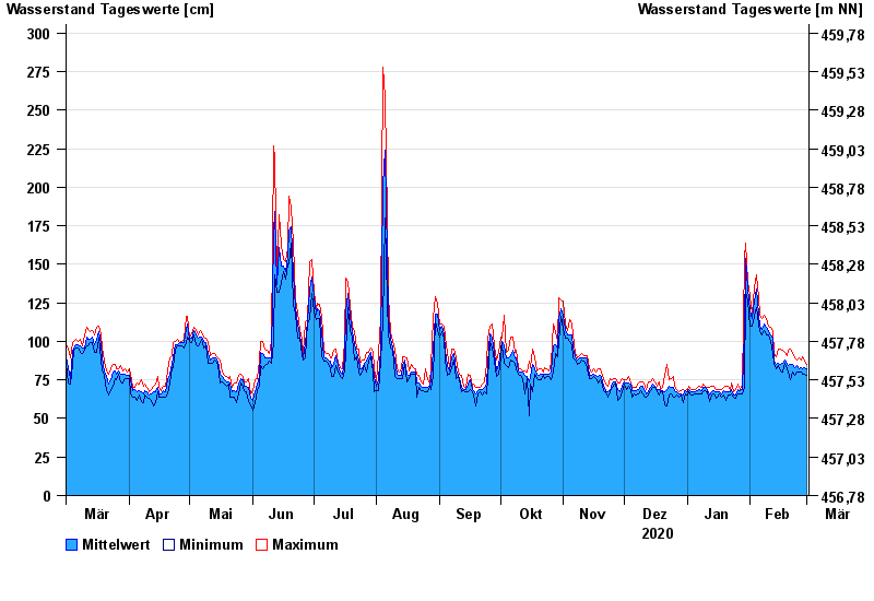
Chart of year Augsburg u. d. Wertachmündung / Lech
Waterlevel from 01.03.2020 to 01.03.2021
note
Abflussermittlung bei Hochwasser durch Geschiebeverlagerung beeinflusst
- 24.08.2005 Wasserstand: 559 cm
- 11.08.1970 Wasserstand: 556 cm
- 22.05.1999 Wasserstand: 553 cm
- 24.07.1966 Wasserstand: 482 cm
- 11.06.1965 Wasserstand: 475 cm
| Date | Mean value [cm] | Maximum [cm] | Minimum [cm] |
|---|---|---|---|
| 01.03.2021 | 82 | 85 | 78 |
| 28.02.2021 | 83 | 87 | 79 |
| 27.02.2021 | 82 | 90 | 79 |
| 26.02.2021 | 83 | 88 | 80 |
| 25.02.2021 | 82 | 89 | 80 |
| 24.02.2021 | 84 | 88 | 80 |
| 23.02.2021 | 83 | 89 | 78 |
© Bayerisches Landesamt für Umwelt 2024