
- Start >
- Rivers >
- Waterlevel >
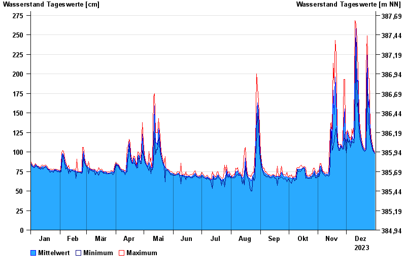
- Inn >
- Engfurt >
- Chart of year

Chart of year Engfurt / Isen
Waterlevel from 01.01.2023 to 31.12.2023
note
zeitweise Beeinflussung durch Kraftwerksbetrieb möglich
- 02.02.1985 Wasserstand: 386 cm
- 31.01.1982 Wasserstand: 365 cm
- 03.08.1991 Wasserstand: 358 cm
- 02.06.2013 Wasserstand: 352 cm
- 02.03.1987 Wasserstand: 346 cm
| Date | Mean value [cm] | Maximum [cm] | Minimum [cm] |
|---|---|---|---|
| 31.12.2023 | 99 | 100 | 98 |
| 30.12.2023 | 101 | 102 | 100 |
| 29.12.2023 | 104 | 106 | 102 |
| 28.12.2023 | 108 | 111 | 105 |
| 27.12.2023 | 113 | 118 | 110 |
| 26.12.2023 | 125 | 134 | 117 |
| 25.12.2023 | 167 | 194 | 134 |
© Bayerisches Landesamt für Umwelt 2024