
- Start >
- Rivers >
- Waterlevel >
- Inn >
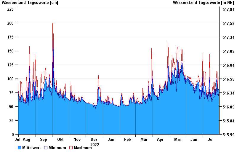
- Berchtesgaden-Klärwerk >
- Chart of year

Chart of year Berchtesgaden-Klärwerk / Berchtesgadener Ache
Waterlevel from 31.07.2022 to 30.07.2023
- 17.07.2021 Wasserstand: 383 cm
- 02.06.2013 Wasserstand: 312 cm
- 12.08.2002 Wasserstand: 295 cm
- 26.06.1995 Wasserstand: 286 cm
- 11.07.2005 Wasserstand: 277 cm
| Date | Mean value [cm] | Maximum [cm] | Minimum [cm] |
|---|---|---|---|
| 30.07.2023 | 82 | 103 | 67 |
| 29.07.2023 | 79 | 102 | 74 |
| 28.07.2023 | 76 | 80 | 72 |
| 27.07.2023 | 88 | 112 | 72 |
| 26.07.2023 | 100 | 113 | 75 |
| 25.07.2023 | 92 | 97 | 86 |
| 24.07.2023 | 77 | 91 | 71 |
© Bayerisches Landesamt für Umwelt 2024