
- Start >
- Rivers >
- Waterlevel >
- Inn >
- Berchtesgaden-Klärwerk >
- Chart of year

Chart of year Berchtesgaden-Klärwerk / Berchtesgadener Ache
Waterlevel from 31.07.2020 to 30.07.2021
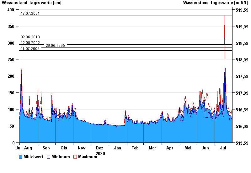
- 17.07.2021 Wasserstand: 383 cm
- 02.06.2013 Wasserstand: 312 cm
- 12.08.2002 Wasserstand: 295 cm
- 26.06.1995 Wasserstand: 286 cm
- 11.07.2005 Wasserstand: 277 cm
| Date | Mean value [cm] | Maximum [cm] | Minimum [cm] |
|---|---|---|---|
| 30.07.2021 | 79 | 98 | 73 |
| 29.07.2021 | 75 | 83 | 73 |
| 28.07.2021 | 80 | 91 | 74 |
| 27.07.2021 | 83 | 94 | 76 |
| 26.07.2021 | 79 | 94 | 69 |
| 25.07.2021 | 95 | 98 | 89 |
| 24.07.2021 | 91 | 106 | 81 |
© Bayerisches Landesamt für Umwelt 2024