
- Start >
- Rivers >
- Waterlevel >
- Inn >
- Berchtesgaden-Klärwerk >
- Chart of year

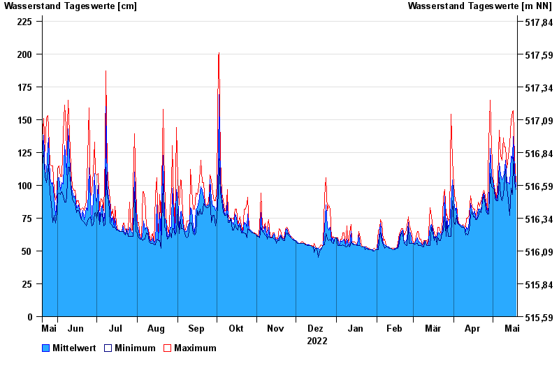
Chart of year Berchtesgaden-Klärwerk / Berchtesgadener Ache
Waterlevel from 20.05.2022 to 19.05.2023
- 17.07.2021 Wasserstand: 383 cm
- 02.06.2013 Wasserstand: 312 cm
- 12.08.2002 Wasserstand: 295 cm
- 26.06.1995 Wasserstand: 286 cm
- 11.07.2005 Wasserstand: 277 cm
| Date | Mean value [cm] | Maximum [cm] | Minimum [cm] |
|---|---|---|---|
| 19.05.2023 | 99 | 102 | 97 |
| 18.05.2023 | 112 | 121 | 102 |
| 17.05.2023 | 137 | 157 | 121 |
| 16.05.2023 | 120 | 156 | 93 |
| 15.05.2023 | 122 | 150 | 98 |
| 14.05.2023 | 101 | 131 | 77 |
| 13.05.2023 | 102 | 122 | 89 |
© Bayerisches Landesamt für Umwelt 2024