
- Start >
- Rivers >
- Waterlevel >
- Iller - Lech - Bodensee >
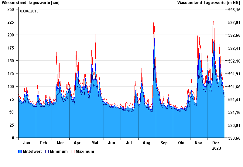
- Türkheim >
- Chart of year

Chart of year Türkheim / Wertach
Waterlevel from 01.01.2023 to 31.12.2023
note
Beeinflussung durch Kraftwerksbetrieb
- 23.08.2005 Wasserstand: 309 cm
- 12.08.2002 Wasserstand: 291 cm
- 02.06.2013 Wasserstand: 277 cm
- 06.08.2010 Wasserstand: 252 cm
- 03.06.2010 Wasserstand: 243 cm
| Date | Mean value [cm] | Maximum [cm] | Minimum [cm] |
|---|---|---|---|
| 31.12.2023 | 89 | 96 | 80 |
| 30.12.2023 | 91 | 94 | 84 |
| 29.12.2023 | 94 | 102 | 90 |
| 28.12.2023 | 103 | 109 | 99 |
| 27.12.2023 | 110 | 120 | 103 |
| 26.12.2023 | 115 | 121 | 101 |
| 25.12.2023 | 124 | 130 | 116 |
© Bayerisches Landesamt für Umwelt 2024