
- Start >
- Rivers >
- Waterlevel >
- Iller - Lech - Bodensee >
- Neu Ulm, Bad Held >
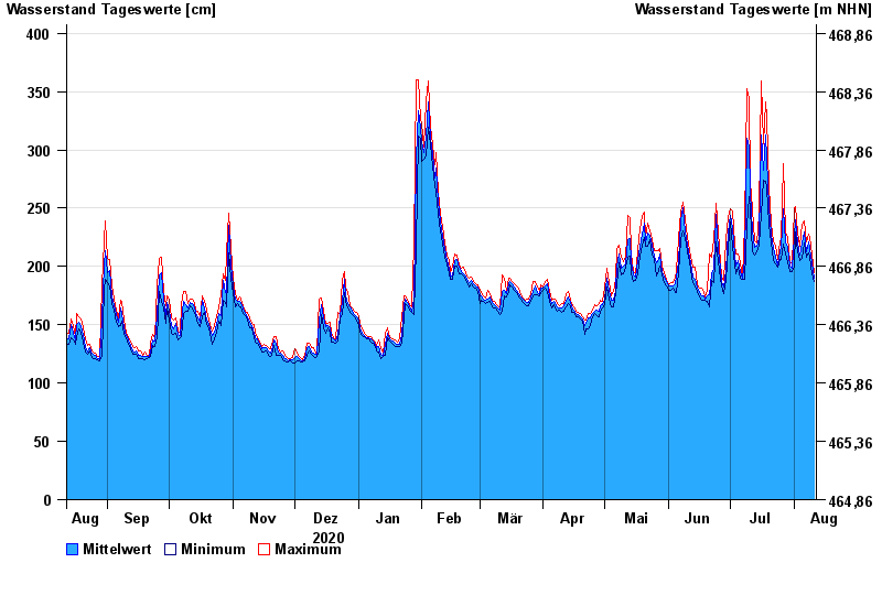
- Chart of year

Chart of year Neu Ulm, Bad Held / Donau
Waterlevel from 12.08.2020 to 11.08.2021
ACHTUNG!
Pegel durch außerordentlichen Kraftwerksbetrieb beeinflusst.
- 23.05.1999 Wasserstand: 571 cm
- 24.08.2005 Wasserstand: 543 cm
- 03.06.2013 Wasserstand: 502 cm
- 16.02.1990 Wasserstand: 471 cm
- 13.08.2002 Wasserstand: 469 cm
| Date | Mean value [cm] | Maximum [cm] | Minimum [cm] |
|---|---|---|---|
| 11.08.2021 | 190 | 195 | 187 |
| 10.08.2021 | 203 | 211 | 194 |
| 09.08.2021 | 215 | 225 | 208 |
| 08.08.2021 | 221 | 228 | 212 |
| 07.08.2021 | 213 | 221 | 208 |
| 06.08.2021 | 230 | 239 | 220 |
| 05.08.2021 | 220 | 236 | 207 |
© Bayerisches Landesamt für Umwelt 2024