
- Start >
- Rivers >
- Waterlevel >
- Oberer Main - Elbe >
- Schönstädt >
- Chart of year

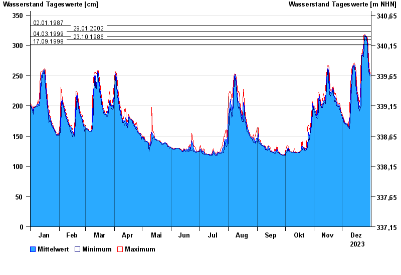
Chart of year Schönstädt / Itz
Waterlevel from 01.01.2023 to 31.12.2023
note
Abfluss ohne Ausleitung über den ehemaligenTriebwerkskanal
- 02.01.1987 Wasserstand: 332 cm
- 29.01.2002 Wasserstand: 323 cm
- 04.03.1999 Wasserstand: 314 cm
- 23.10.1986 Wasserstand: 309 cm
- 17.09.1998 Wasserstand: 302 cm
| Date | Mean value [cm] | Maximum [cm] | Minimum [cm] |
|---|---|---|---|
| 31.12.2023 | 251 | 253 | 249 |
| 30.12.2023 | 257 | 263 | 253 |
| 29.12.2023 | 278 | 295 | 262 |
| 28.12.2023 | 302 | 312 | 295 |
| 27.12.2023 | 314 | 315 | 311 |
| 26.12.2023 | 316 | 316 | 315 |
| 25.12.2023 | 317 | 318 | 316 |
© Bayerisches Landesamt für Umwelt 2024