
- Start >
- Rivers >
- Waterlevel >
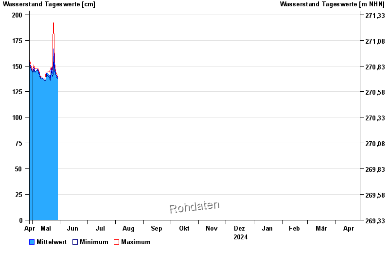
- Oberer Main - Elbe >
- Schönbrunn >
- Chart of year

Chart of year Schönbrunn / Rauhe Ebrach
Waterlevel from 28.04.2024 to 27.04.2025
note
Beeinflussung des Abflusses aufgrund Hindernisse im Unterlauf
- 26.01.1995 Wasserstand: 369 cm
- 10.07.2021 Wasserstand: 363 cm
- 31.05.2013 Wasserstand: 361 cm
- 13.01.2011 Wasserstand: 360 cm
- 21.12.1993 Wasserstand: 360 cm
| Date | Mean value [cm] | Maximum [cm] | Minimum [cm] |
|---|---|---|---|
| 08.05.2024 | 145 | 146 | 144 |
| 07.05.2024 | 147 | 148 | 146 |
| 06.05.2024 | 146 | 148 | 146 |
| 05.05.2024 | 145 | 148 | 144 |
| 04.05.2024 | 145 | 147 | 144 |
| 03.05.2024 | 149 | 151 | 147 |
| 02.05.2024 | 145 | 149 | 144 |
© Bayerisches Landesamt für Umwelt 2024