
- Start >
- Rivers >
- Waterlevel >
- Oberer Main - Elbe >
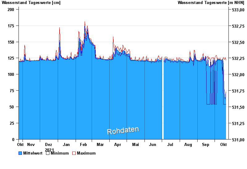
- Fahrenbühl >
- Chart of year

Chart of year Fahrenbühl / Lamitz
Waterlevel from 25.10.2021 to 24.10.2022
note
Schlechte Netzanbindung
- 07.02.1984 Wasserstand: 206 cm
- 12.02.2005 Wasserstand: 205 cm
- 23.01.1995 Wasserstand: 205 cm
- 14.01.2011 Wasserstand: 203 cm
- 03.01.2003 Wasserstand: 201 cm
| Date | Mean value [cm] | Maximum [cm] | Minimum [cm] |
|---|---|---|---|
| 20.10.2022 | 73 | 122 | 54 |
| 19.10.2022 | 62 | 126 | 54 |
| 18.10.2022 | 65 | 123 | 54 |
| 17.10.2022 | 81 | 123 | 54 |
| 16.10.2022 | 116 | 126 | 54 |
| 15.10.2022 | 123 | 124 | 122 |
| 14.10.2022 | 123 | 124 | 100 |
© Bayerisches Landesamt für Umwelt 2024