
- Start >
- Rivers >
- Discharge >
- Untere Donau >
- Erlachleiten >
- Chart of year

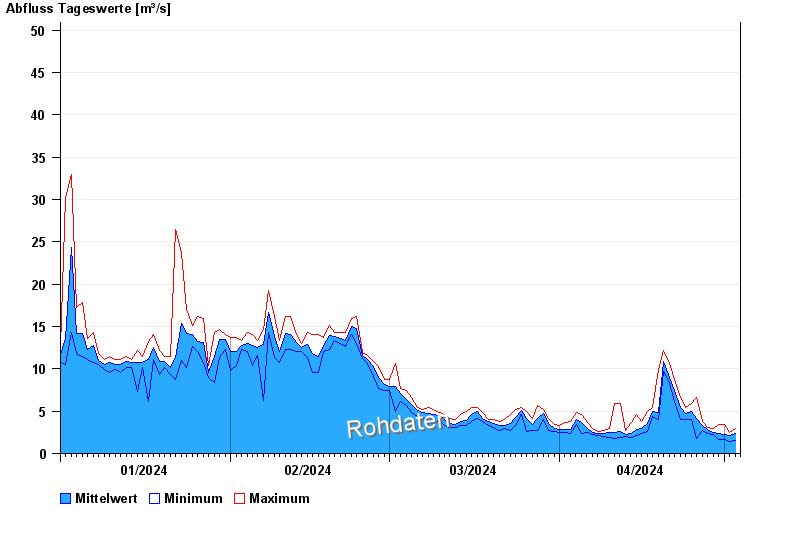
Chart of year Erlachleiten / Erlau
Discharge from 01.01.2024 to 03.05.2024
- 25.06.2016 Abfluss: 157 m³/s
- 20.06.2012 Abfluss: 89,1 m³/s
- 06.07.2009 Abfluss: 62,5 m³/s
- 20.06.2012 Abfluss: 62,4 m³/s
- 14.01.2011 Abfluss: 58 m³/s
| Date | Mean value [m³/s] | Maximum [m³/s] | Minimum [m³/s] |
|---|---|---|---|
| 03.05.2024 | 2.18 | 2.34 | 1.96 |
| 02.05.2024 | 2.14 | 2.48 | 1.42 |
| 01.05.2024 | 2.22 | 3.43 | 1.63 |
| 30.04.2024 | 2.33 | 3.43 | 1.63 |
| 29.04.2024 | 2.49 | 2.92 | 2.2 |
| 28.04.2024 | 2.78 | 3.08 | 2.34 |
| 27.04.2024 | 3.26 | 3.8 | 2.77 |
 more data more data | |||

© Bayerisches Landesamt für Umwelt 2024