
- Start >
- Rivers >
- Discharge >
- Naab - Regen >
- Untereppenried >
- Chart of year

Chart of year Untereppenried / Ascha
Discharge from 01.01.2021 to 31.12.2021
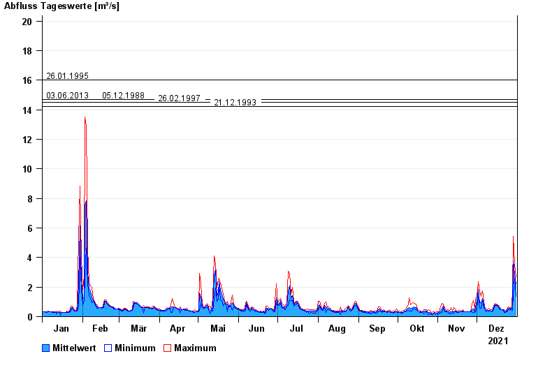
- 26.01.1995 Abfluss: 16 m³/s
- 03.06.2013 Abfluss: 14,7 m³/s
- 05.12.1988 Abfluss: 14,7 m³/s
- 26.02.1997 Abfluss: 14,5 m³/s
- 21.12.1993 Abfluss: 14,2 m³/s
| Date | Mean value [m³/s] | Maximum [m³/s] | Minimum [m³/s] |
|---|---|---|---|
| 31.12.2021 | 2.2 | 2.71 | 1.36 |
| 30.12.2021 | 2.88 | 3.54 | 2.59 |
| 29.12.2021 | 3.79 | 5.45 | 1.57 |
| 28.12.2021 | 0.677 | 1.57 | 0.412 |
| 27.12.2021 | 0.49 | 0.491 | 0.49 |
| 26.12.2021 | 0.56 | 0.617 | 0.491 |
| 25.12.2021 | 0.568 | 0.661 | 0.451 |
© Bayerisches Landesamt für Umwelt 2024