
- Start >
- Rivers >
- Discharge >
- Naab - Regen >
- Schlehdorf >
- Chart of year

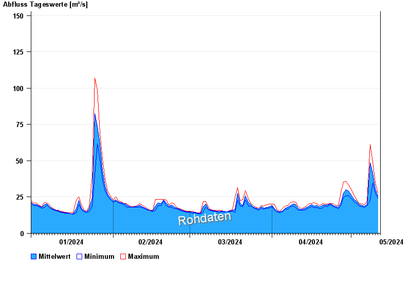
Chart of year Schlehdorf / Loisach
Discharge from 01.01.2024 to 11.05.2024
- 22.05.1999 Abfluss: 360 m³/s
- 08.07.1946 Abfluss: 334 m³/s
- 23.08.2005 Abfluss: 330 m³/s
- 31.05.1940 Abfluss: 330 m³/s
- 11.08.1970 Abfluss: 317 m³/s
| Date | Mean value [m³/s] | Maximum [m³/s] | Minimum [m³/s] |
|---|---|---|---|
| 11.05.2024 | 28.1 | 28.1 | 28.1 |
| 10.05.2024 | 30.3 | 34.7 | 27.5 |
| 09.05.2024 | 41.6 | 49.3 | 34.7 |
| 08.05.2024 | 48.4 | 61.2 | 22.7 |
| 07.05.2024 | 20 | 22.1 | 19.3 |
| 06.05.2024 | 18.9 | 19.7 | 17.8 |
| 05.05.2024 | 19.1 | 20.2 | 18.3 |
 more data more data | |||

© Bayerisches Landesamt für Umwelt 2024