
- Start >
- Rivers >
- Discharge >
- Unterer Main >
- Reupelsdorf >
- Chart of year

Chart of year Reupelsdorf / Schwarzach
Discharge from 09.05.2021 to 08.05.2022
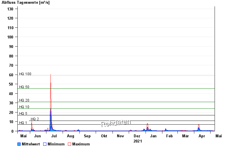
- HQ1 7 m³/s
- HQ2 11 m³/s
- HQ5 17 m³/s
- HQ10 24 m³/s
- HQ20 31 m³/s
- HQ50 45 m³/s
- HQ100 59 m³/s
| Date | Mean value [m³/s] | Maximum [m³/s] | Minimum [m³/s] |
|---|---|---|---|
| 08.05.2022 | 0.333 | 0.343 | 0.323 |
| 07.05.2022 | 0.349 | 0.386 | 0.323 |
| 06.05.2022 | 0.378 | 0.429 | 0.343 |
| 05.05.2022 | 0.415 | 0.493 | 0.404 |
| 04.05.2022 | 0.429 | 0.448 | 0.404 |
| 03.05.2022 | 0.451 | 0.493 | 0.426 |
| 02.05.2022 | 0.486 | 0.563 | 0.47 |
© Bayerisches Landesamt für Umwelt 2024