

Master data Anger
Site number: 18346000
Community: Ramerberg
District: Rosenheim
Operator:  Wasserwirtschaftsamt Rosenheim
Body of water: Attel
Catchment: 249.60 km2
River chainage: 2.20 km
Easting: 734702 (ETRS89 / UTM Zone 32N)
Northing: 5323747
Gauge zero point: 434.50 m NN (DHHN12)
Picture of the measurement site
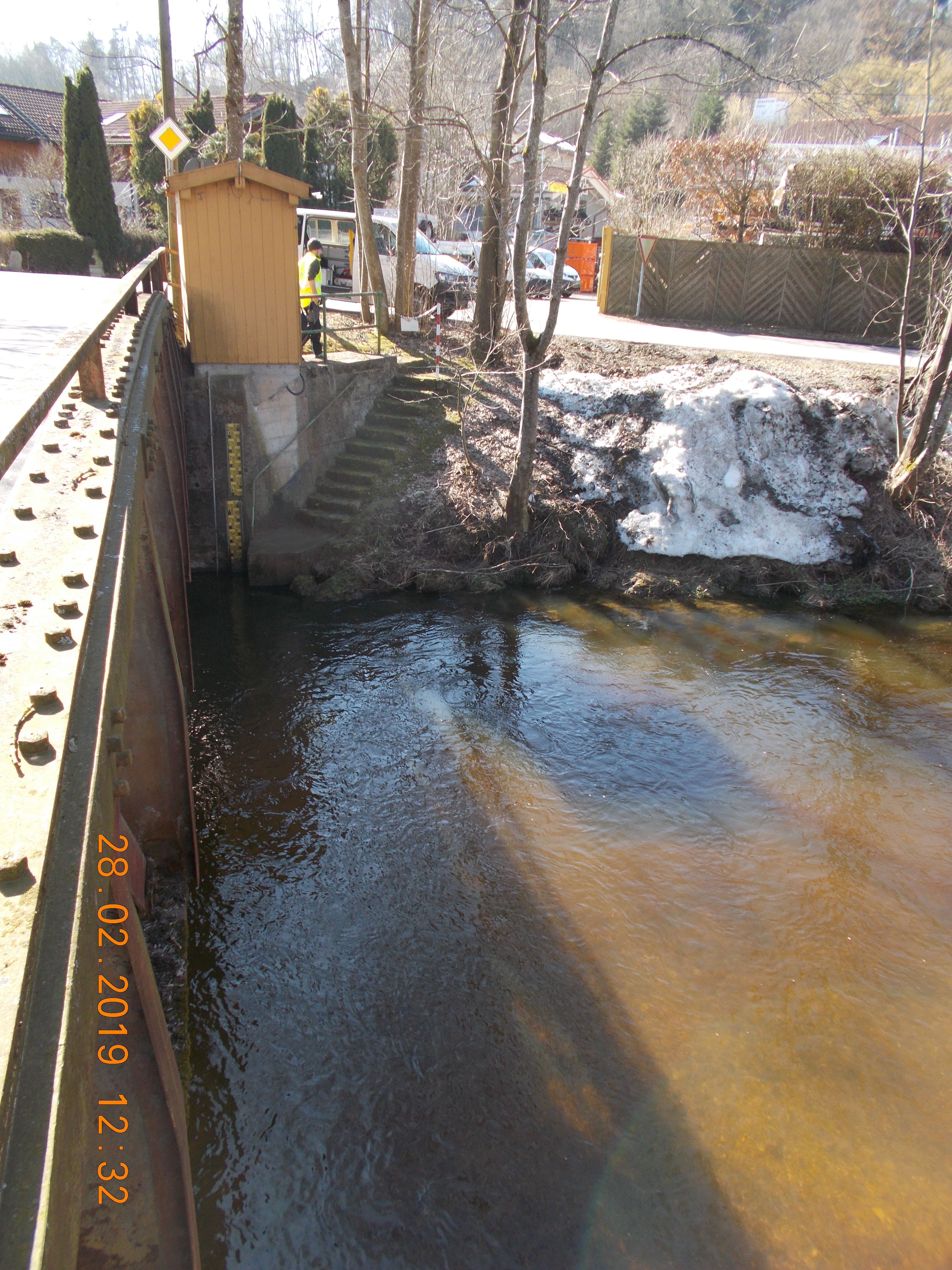
Location of the station Anger / Attel
| Measurement site | Category |
|---|---|
 Berg Berg | Rivers: Runoff, Waterlevel |
| Operding | Rivers: Runoff, Waterlevel |
| Rosenheim o.d. Mangfallmündung | Rivers: Runoff, Waterlevel, Water temperature, Water temperature, Suspended sediment |
| Wasserburg | Rivers: Runoff, Waterlevel, Water temperature, Water temperature, Suspended sediment |
| Stephanskirchen | Rivers: Runoff, Waterlevel |
| Bad Aibling Willinger Brücke | Rivers: Runoff, Waterlevel, Water temperature, Water temperature |
| Bad Aibling (virtuell) | Rivers: Runoff |
| Rosenheim | Rivers: Runoff, Waterlevel, Water temperature, Water temperature |
| Rosenheim (virtuell) | Rivers: Runoff |
| Beyharting | Rivers: Runoff, Waterlevel |
| Bad Aibling | Rivers: Runoff, Waterlevel |
| Bad Aibling Q | Rivers: Runoff |
| Bad Feilnbach | Rivers: Runoff, Waterlevel |
| Bad Feilnbach | Rivers: Runoff, Waterlevel |
| Hohenofen | Rivers: Runoff, Waterlevel, Water temperature, Water temperature |
| Au b. Bad Aibling | Rivers: Runoff, Waterlevel, Water temperature, Water temperature |
| Rosenheim Q | Rivers: Runoff |
| Weichselbaum | Rivers: Runoff, Waterlevel |
| Aßling | Rivers: Runoff, Waterlevel, Water temperature, Water temperature |
| Anger | Rivers: Runoff, Waterlevel |
| Weg | Rivers: Runoff, Waterlevel |
| Großschwindau | Rivers: Runoff, Waterlevel |
| Bernau | Rivers: Runoff, Waterlevel, Water temperature, Water temperature |
| Aschau | Rivers: Runoff, Waterlevel, Water temperature, Water temperature |
| Prien | Rivers: Runoff, Waterlevel |
| Prien (virtuell) | Rivers: Runoff |
| Dickertsmühle | Rivers: Runoff, Waterlevel |
| Rosenheim u.d. Mangfallmündung | Rivers: Waterlevel |
| Bad Aibling | Rivers: Waterlevel |
| Rosenheim | Rivers: Waterlevel, Water temperature, Water temperature |
| Krottenmühl | Lakes: Waterlevel |
| Stock | Lakes: Waterlevel, Water temperature, Water temperature |
| Pelham | Lakes: Waterlevel |
| Eggstätt | Lakes: Waterlevel |
| Kirchdorf Bruecke | Rivers: Chemistry |
| Pegel Bad Aibling | Rivers: Chemistry |
| Brücke Heiligenblut | Rivers: Chemistry |
| Brücke östl. Pfaffenhofen | Rivers: Chemistry, Biology |
| uh. Brücke Unterübermoos | Rivers: Chemistry, Biology |
| Brücke bei Aidenbach | Rivers: Chemistry, Biology |
| oh. Brücke Rain | Rivers: Chemistry, Biology |
| oh. Brücke Oelmühle | Rivers: Chemistry, Biology |
| 05_Bad Aibling | Rivers: Chemistry |
| 05_Königswart | Rivers: Chemistry |
| Sims 2 Krottenhausmühl | Rivers: Chemistry |
| Holzen | Rivers: Chemistry |
| uh. Brücke Sportplatz Edling | Rivers: Chemistry, Biology |
| Br Embach Esterndorf | Rivers: Chemistry, Biology |
| Brücke Ahornstraße | Rivers: Chemistry |
| Brücke Gars | Rivers: Chemistry |
| Tiefste Stelle, Hauptbecken | Lakes: Chemistry, Biology |
| 02_200m oberhalb Einl. Birzle | Rivers: Chemistry, Biology |
| 06_Untermühle | Rivers: Chemistry |
| Tiefste Stelle | Lakes: Chemistry, Biology |
| Tiefste Stelle | Lakes: Chemistry, Biology |
| Tiefste Stelle | Lakes: Chemistry, Biology |
| Tiefste Stelle | Lakes: Chemistry, Biology |
| uh. Triftbach | Rivers: Chemistry, Biology |
| Furth nach Dettendorf | Rivers: Chemistry |
| uh. Brücke Heiming | Rivers: Chemistry, Biology |
| uh. Br. Pausmühle | Rivers: Chemistry, Biology |
| Wasserburg, uh Kapuzinerinsel | Rivers: Chemistry, Biology |
| zwischen Thann und Litzlkirchen | Rivers: Chemistry, Biology |
| Brücke St. 2092, Pegel Prien | Rivers: Chemistry, Biology |
| oh. Straßenbrücke | Rivers: Chemistry, Biology |
| Brücke bei Hart | Rivers: Chemistry |
| 03_Staustufe Feldkirchen | Rivers: Chemistry |
| Steg oh. Aßling Flkm. 30,8 | Rivers: Chemistry, Biology |
| unterhalb Steinhöring | Rivers: Chemistry |
| oh. Brücke Moosmühle | Rivers: Chemistry, Biology |
| oh. Mündung Kesselbach | Rivers: Chemistry, Biology |
| Ablauf aus dem Hartsee | Rivers: Chemistry |
| 03_Einmündung in Kalten | Rivers: Chemistry |
| 04_Br.Mietraching | Rivers: Chemistry |
| 04_Br. Kaltenbrunn | Rivers: Chemistry |
| 07_oberh. Mündung | Rivers: Chemistry |
| 05_Engersdorf | Rivers: Chemistry |
| Hofmühle | Rivers: Chemistry |
| Rohrdorfer Ache vor Mdg | Rivers: Chemistry |
| uh. Brücke Weitermühle | Rivers: Chemistry, Biology |
| Br. uh Willing | Rivers: Chemistry |
| 100m oh. Mündung Rohrdorfer Achen | Rivers: Chemistry, Biology |
| Brücke uh. Freimehring | Rivers: Chemistry, Biology |
| uh Kraftwerk Achen | Rivers: Chemistry |
| 03_v.Mündung | Rivers: Chemistry |
| Thalkirchner A Brücke vor Mündung | Rivers: Chemistry |
| 250 m oh. Brücke Heufeld-Westerham | Rivers: Biology |
| Murnholz _ Pirach | Rivers: Biology |
| Anzenberg | Rivers: Biology |
| uh Oberschwillach | Rivers: Biology |
| oh. Br. Mietraching | Rivers: Biology |
| oh. Brücke Forsthütte | Rivers: Biology |
| oh. Brücke Henneleiten, Mst.4 | Rivers: Biology |
| 04_nach Lamplstätt | Rivers: Biology |
| 800m uh Oberstaudhausen | Rivers: Biology |
| uh Oberschwillach | Rivers: Biology |
| Br. Unterheufeldmühle | Rivers: Biology |
| 500 m uh. A8 | Rivers: Biology |
| uh. Brücke bei Schonstett | Rivers: Biology |
| uh. Pegelhaus Stephanskirchen | Rivers: Biology |
| 200m uh. Waldsee (bei Inn km 174,4) | Rivers: Biology |
| Bucht bei Langbürgen, Transekt 1 | Lakes: Biology |
| südl. der Insel, Transekt 2 | Lakes: Biology |
| Insel Nordseite, Transekt 3 | Lakes: Biology |
| Bucht bei Westerhausen, Transekt 4 | Lakes: Biology |
| Stock, Transekt 5 | Lakes: Biology |
| Westl. Nordufer, Transekt 6 | Lakes: Biology |
| Bucht bei Schlicht, Transekt 7 | Lakes: Biology |
| südl. zufluss Thaler See, Transekt 8 | Lakes: Biology |
| Transekt 02 Seegrundstück mit Steg, 2 Tannen | Lakes: Biology |
| Transekt 03 zw. Baumreihen, in 100m Häuser | Lakes: Biology |
| Transekt 04 Westufer zw. Steg und Bootshütte, vor Schilfgürtel | Lakes: Biology |
| Transekt 05 Mischwald, links neben kl. Schneise | Lakes: Biology |
| Transekt 06 Westufer, Wald, ca. 100 m Bootshaus | Lakes: Biology |
| Transekt 07 zw. Steilwänden | Lakes: Biology |
| Transekt 08 vor Schilf, links v. Steg | Lakes: Biology |
| Transekt 09 vor bewaldetem Hügel | Lakes: Biology |
| Transekt 10 links v. Campingplatz | Lakes: Biology |
| Transekt 10 | Lakes: Biology |
| Transekt 11 | Lakes: Biology |
| Transekt 12 | Lakes: Biology |
| Transekt 13 | Lakes: Biology |
| Transekt 14 | Lakes: Biology |
| Transekt 15 | Lakes: Biology |
| Transekt 16 | Lakes: Biology |
| Transekt 17 | Lakes: Biology |
| Transekt 24 | Lakes: Biology |
| Transekt 25 | Lakes: Biology |
| Transekt 31 | Lakes: Biology |
| Transekt 32 | Lakes: Biology |
| Transekt 33 | Lakes: Biology |
| Transekt 34 | Lakes: Biology |
| Transekt 35 | Lakes: Biology |
| Transekt 1 | Lakes: Biology |
| Transekt 2 | Lakes: Biology |
| Transekt 3 | Lakes: Biology |
| Transekt 4 | Lakes: Biology |
| Transekt 5 | Lakes: Biology |
| Transekt 6 | Lakes: Biology |
| Transekt 1 | Lakes: Biology |
| Transekt 2 | Lakes: Biology |
| Transekt 3 | Lakes: Biology |
| Transekt 4 | Lakes: Biology |
| Transekt 1 | Lakes: Biology |
| Transekt 2 | Lakes: Biology |
| Transekt 3 | Lakes: Biology |
| Transekt 4 | Lakes: Biology |
| Transekt 5 | Lakes: Biology |
| Transekt 6 | Lakes: Biology |
| Transekt 01 | Lakes: Biology |
| WIECHS R 3 | Groundwater: Upper groundwater layer |
| Oberdorfen T 14f | Groundwater: Deep groundwater layer |
| OBERDORFEN Q 19 | Groundwater: Upper groundwater layer |
| FORSTERN BR. 1 alt | Groundwater: Upper groundwater layer |
| STADT KOLBERMOOR 15A | Groundwater: Upper groundwater layer |
| PASTETTEN Q 18 | Groundwater: Upper groundwater layer |
| PASTETTEN T 13 | Groundwater: Deep groundwater layer |
| POLIZEI 9 | Groundwater: Upper groundwater layer |
| ALPENWEG 27 | Groundwater: Upper groundwater layer |
| Oberdorfen T 14t | Groundwater: Deep groundwater layer |
| WIMPASING 611A P52080 | Groundwater: Upper groundwater layer |
| SENDLING 301 | Groundwater: Upper groundwater layer |
| TURNERWEG 5 | Groundwater: Upper groundwater layer |
| ARNULFSTR. 6A | Groundwater: Upper groundwater layer |
| STAATSWALD 9 | Groundwater: Upper groundwater layer |
| UMSPANNWERK PANG 13 | Groundwater: Upper groundwater layer |
| HEILIG BLUT 14 | Groundwater: Upper groundwater layer |
| SCHLARBHOFEN 16 | Groundwater: Upper groundwater layer |
| AISINGER LANDSTR. 30 | Groundwater: Upper groundwater layer |
| LEITZACHSTRASSE 31 | Groundwater: Upper groundwater layer |
| FERNM.A.AICHERSTR.5 18 | Groundwater: Upper groundwater layer |
| SPORTPL.SCHWAIG 19 | Groundwater: Upper groundwater layer |
| ENDORFER AU 20 | Groundwater: Upper groundwater layer |
| OBERWOEHR-MANGF.AU 21A | Groundwater: Upper groundwater layer |
| FT-SPORTPL. 22 | Groundwater: Upper groundwater layer |
| ZOLLAMT 23A | Groundwater: Upper groundwater layer |
| WWA 24A | Groundwater: Upper groundwater layer |
| RIEDERGARTEN 25 | Groundwater: Upper groundwater layer |
| KRANKENH.PARKPL. 26 | Groundwater: Upper groundwater layer |
| PFAFFENHOFEN 120 | Groundwater: Upper groundwater layer |
| ELSBETH / STADL 91 | Groundwater: Upper groundwater layer |
| Hohenlinden 2 | Groundwater: Upper groundwater layer |
| REICHERTSHEIM T1 | Groundwater: Deep groundwater layer |
| Kumpfmühlquelle 1+2 | Groundwater: Flow of well, Temperature of springs |
| SUEDOE.SCHWABERW. 304A | Groundwater: Upper groundwater layer |
| HOHENLINDEN 307 | Groundwater: Upper groundwater layer |
| BF.GRAFING 202 | Groundwater: Upper groundwater layer |
| EBERSB.FORST 1 525 | Groundwater: Upper groundwater layer |
| EBERSB.FORST 2 526 | Groundwater: Upper groundwater layer |
| FORSTINNING 511 | Groundwater: Upper groundwater layer |
| HOHENLINDEN 904 | Groundwater: Upper groundwater layer |
| VOLKSSCHULE 1 | Groundwater: Upper groundwater layer |
| SPORTPLATZ 2 | Groundwater: Upper groundwater layer |
| TRAFO HOLZHOFWEG 6 | Groundwater: Upper groundwater layer |
| BAHNBETRIEBSGEL. 7 | Groundwater: Upper groundwater layer |
| FLUSSMEISTERSTELLE 10 | Groundwater: Upper groundwater layer |
| LEDERERZEILE 11 | Groundwater: Upper groundwater layer |
| AMTSGERICHT 12 | Groundwater: Upper groundwater layer |
| LEBZELTER 13 | Groundwater: Upper groundwater layer |
| HUNDT,WEBERZIPFEL 15 | Groundwater: Upper groundwater layer |
| AUF DER BURG 19 | Groundwater: Upper groundwater layer |
| FEUERWEHRHAUS 20 | Groundwater: Upper groundwater layer |
| VOLKSSCHULE 1A | Groundwater: Upper groundwater layer |
| SPORTPLATZ 2A | Groundwater: Upper groundwater layer |
| BAHNTUNNEL 16A | Groundwater: Upper groundwater layer |
| WAITH R 4 | Groundwater: Upper groundwater layer |
| MIETRACHING R 13 | Groundwater: Upper groundwater layer |
| WEIDACH R 20 | Groundwater: Upper groundwater layer |
| BERBLING R 21 | Groundwater: Upper groundwater layer |
| ORTHOFEN R 23 | Groundwater: Upper groundwater layer |
| HOEGLING R 24 | Groundwater: Upper groundwater layer |
| MARKFELD R 26 | Groundwater: Upper groundwater layer |
| ADLFURT R 27 | Groundwater: Upper groundwater layer |
| MAXLRAIN R 30 | Groundwater: Upper groundwater layer |
| HINRICHSSEGEN R 31 | Groundwater: Upper groundwater layer |
| UNT.-HEUFELD R 32 | Groundwater: Upper groundwater layer |
| HOEGLING R 41 | Groundwater: Upper groundwater layer |
| OBERADLFURT R 42 | Groundwater: Upper groundwater layer |
| BERBLING R 45 | Groundwater: Upper groundwater layer |
| SUED.WILLINGERAU R 46 | Groundwater: Upper groundwater layer |
| GOETTING MANGF. 50 | Groundwater: Upper groundwater layer |
| BRUCKMUEHL U.STR. 51 | Groundwater: Upper groundwater layer |
| ASSLING 65/206 | Groundwater: Upper groundwater layer |
| AISING EINOEDE 353A | Groundwater: Upper groundwater layer |
| PANG 354 | Groundwater: Upper groundwater layer |
| BAD AIBLING R 28 | Groundwater: Upper groundwater layer |
| THUERHAM/AIBLING R 43 | Groundwater: Upper groundwater layer |
| FUERSTAETTER-SCHULE 1 | Groundwater: Upper groundwater layer |
| ESV-SPORTPLATZ 2 | Groundwater: Upper groundwater layer |
| FINSTERW.-GEIGELST. 3 | Groundwater: Upper groundwater layer |
| AUTOHAUS WENDELST. 4 | Groundwater: Upper groundwater layer |
| GASTHAUS WALDECK 7 | Groundwater: Upper groundwater layer |
| MANGFALLWEG 24 8A | Groundwater: Upper groundwater layer |
| FUCHSBICHLW. 9U.11 12 | Groundwater: Upper groundwater layer |
| BAUHOF BAD AIB. KO 37 | Groundwater: Upper groundwater layer |
| KUTTERLINGERWEG KO 38 | Groundwater: Upper groundwater layer |
| BLUMENSTRASSE KO 39A | Groundwater: Upper groundwater layer |
| FORSTSTRASSE KO 40 | Groundwater: Upper groundwater layer |
| ST. 2078 ARMCO KO 41 | Groundwater: Upper groundwater layer |
| BRUECKENWIRT KO 42 | Groundwater: Upper groundwater layer |
| SPINNEREI KO 43 | Groundwater: Upper groundwater layer |
| EV. KIRCHE KO 45 | Groundwater: Upper groundwater layer |
| STAATSSTRASSE82 KO 47 | Groundwater: Upper groundwater layer |
| KALTWIES 28 | Groundwater: Upper groundwater layer |
| HAPPINGERSTR. 29 | Groundwater: Upper groundwater layer |
| STRASSENBAUAMT 32 | Groundwater: Upper groundwater layer |
| PAPIERF.NIEDERM. 33 | Groundwater: Upper groundwater layer |
| INNSBRUCKERSTR. 34 | Groundwater: Upper groundwater layer |
| SPORTPL.TSV 1860 35 | Groundwater: Upper groundwater layer |
| DB-FAHRLEITUNGSBAU 36 | Groundwater: Upper groundwater layer |
| REDENFELDEN 17 | Groundwater: Upper groundwater layer |
| Kaltenbach - Kufsteiner Str. 122 | Groundwater: Upper groundwater layer |
| Kaltenbach - Kufsteiner Str. 86 | Groundwater: Upper groundwater layer |
| Kaltenbach - Wallberg Str. 10 | Groundwater: Upper groundwater layer |
| GM1 SCHWIMMBAD KO | Groundwater: Upper groundwater layer |
| GM2 ZUGSPITZSTRASSE KO | Groundwater: Upper groundwater layer |
| GM3 AIBLINGERAU 3 | Groundwater: Upper groundwater layer |
| GM 4 AIBLINGERAU 26 | Groundwater: Upper groundwater layer |
| B6V Vagener Au | Groundwater: Upper groundwater layer |
| AM WALDRAND 1 KO 46 | Groundwater: Upper groundwater layer |
| BAD AIBLING TRIFTB._52A | Groundwater: Upper groundwater layer |
| WEIHENLINDEN R 11A | Groundwater: Upper groundwater layer |
| Aschau iCh GWM 7 | Groundwater: Upper groundwater layer |
| Kupfgrabenquelle I + III | Groundwater: Flow of well, Temperature of springs |
| WESTERHAM,SUEDL. R 7 | Groundwater: Upper groundwater layer |
| WILLINGERAU R44B | Groundwater: Upper groundwater layer |
| WALDHEIM R 25 | Groundwater: Upper groundwater layer |
| WILLING TANNENW.10 49 | Groundwater: Upper groundwater layer |
| WEIHER-WINKELWEG 11 | Groundwater: Upper groundwater layer |
| RIED R 37 | Groundwater: Upper groundwater layer |
| Erding HWS-NW1 | Groundwater: Upper groundwater layer |
| WEINBERGER 4 | Groundwater: Upper groundwater layer |
| 20 KV MAST 5 | Groundwater: Upper groundwater layer |
| ZIEHWEG HAUS NR 1 22 | Groundwater: Upper groundwater layer |
| SCHNAITSEE 588 | Groundwater: Upper groundwater layer |
| HEUFELD R 38 | Groundwater: Upper groundwater layer |
| HEUFELD R 12 | Groundwater: Upper groundwater layer |
| HINZING 411A | Groundwater: Upper groundwater layer |
| Jolling GWM1 18700024 | Groundwater: Upper groundwater layer |
| Erding HWS BSP 1 Neu | Groundwater: Upper groundwater layer |
| DORFEN B 3 | Groundwater: Upper groundwater layer |
| Erding HWS BSP 3 | Groundwater: Upper groundwater layer |
| Pittenhart B8 | Groundwater: Upper groundwater layer |
| Bad Feilnbach GwM 20-02 | Groundwater: Upper groundwater layer |
| 1131773800357 | Groundwater: Chemistry |
| 4110773800020 | Groundwater: Chemistry |
| 1131783700038 | Groundwater: Chemistry |
| 1131793900050 | Groundwater: Chemistry |
| 1131813700022 | Groundwater: Chemistry |
| 1131813700028 | Groundwater: Chemistry |
| 1131813700032 | Groundwater: Chemistry |
| 1131813800204 | Groundwater: Chemistry |
| 1131813800219 | Groundwater: Chemistry |
| 4110783900069 | Groundwater: Chemistry |
| 4110793700014 | Groundwater: Chemistry |
| 4110813900035 | Groundwater: Chemistry |
| 4110814000021 | Groundwater: Chemistry |
| 4120793800030 | Groundwater: Chemistry |
| 4120803800016 | Groundwater: Chemistry |
| 4120814000030 | Groundwater: Chemistry |
| 4110783900022 | Groundwater: Chemistry |
| 4110823700021 | Groundwater: Chemistry |
| 4110803900044 | Groundwater: Chemistry |
| 4110794000022 | Groundwater: Chemistry |
| 4120823700027 | Groundwater: Chemistry |
| 1131773700416 | Groundwater: Chemistry |
| 1131783800228 | Groundwater: Chemistry |
| 1131783900113 | Groundwater: Chemistry |
| 1131793700292 | Groundwater: Chemistry |
| 1131803700173 | Groundwater: Chemistry |
| 1131803900062 | Groundwater: Chemistry |
| 4120803700033 | Groundwater: Chemistry |
| 1131793900117 | Groundwater: Chemistry |
| 1132803700229 | Groundwater: Chemistry |
| 1132783900126 | Groundwater: Chemistry |
| 1131804000135 | Groundwater: Chemistry |
| 1131773700379 | Groundwater: Chemistry |
| 4120783800033 | Groundwater: Chemistry |
| 1131813800492 | Groundwater: Chemistry |
| 4110773805001 | Groundwater: Chemistry |
| 1131823800147 | Groundwater: Chemistry |
| 1132803900144 | Groundwater: Chemistry |
| 1132773900401 | Groundwater: Chemistry |
| 1132783800263 | Groundwater: Chemistry |
| 4120793800096 | Groundwater: Chemistry |
| 1132773900400 | Groundwater: Chemistry |
| 1132783900129 | Groundwater: Chemistry |
| 1131773900407 | Groundwater: Chemistry |
| 1131813800511 | Groundwater: Chemistry |
| Dorfen, Kreis Erding | Meteorology: Precipitation, Snow |
| Feilnbach, Bad | Meteorology: Precipitation, Snow |
| Jettenbach | Meteorology: Precipitation, Snow |
| Samerberg-Geisenkam | Meteorology: Precipitation, Snow |
| Aßling | Meteorology: Precipitation, Snow |
| Osterseeon | Meteorology: Precipitation, Wind, Air temperatur, Air moisture, Global radiation |
| Straß | Meteorology: Precipitation, Wind, Air temperatur, Air moisture, Global radiation |
| Asen | Meteorology: Precipitation, Wind, Air temperatur, Air moisture, Global radiation |
| Reitmehring | Meteorology: Precipitation, Wind, Air temperatur, Air moisture, Global radiation |
| Karolinenfeld | Meteorology: Precipitation, Wind, Air temperatur, Air moisture, Global radiation |
| Bergham | Meteorology: Precipitation, Air temperatur, Air moisture, Global radiation |
| Söllhuben | Meteorology: Precipitation, Wind, Air temperatur, Air moisture, Global radiation |
© Bayerisches Landesamt für Umwelt 2026