
- Start >
- Lakes >
- Waterlevel >
- Isar >
- Schliersee >
- Chart of month

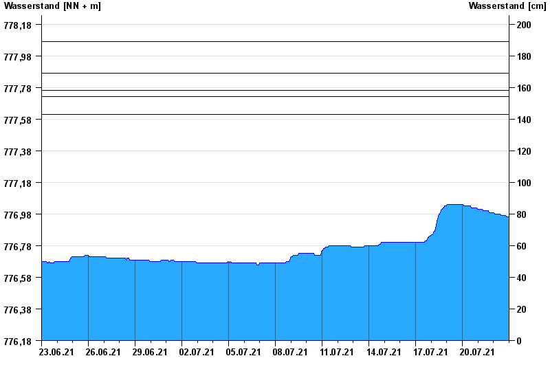
Chart of month Schliersee / Schliersee
Waterlevel from 23.06.2021 to 22.07.2021
- 03.06.2013 Wasserstand: 778,07 m ü. NN
- 24.08.2005 Wasserstand: 777,87 m ü. NN
- 07.06.1995 Wasserstand: 777,76 m ü. NN
- 23.05.1999 Wasserstand: 777,72 m ü. NN
- 20.06.1979 Wasserstand: 777,61 m ü. NN
Linien: keine | Hauptwerte | Meldestufen | mittlerer Seespiegel | Hochwassermarken | historische Ereignisse
| Date | Waterlevel [m above sealevel] |
|---|---|
| 23.07.2021 00:45 | 776.96 |
| 23.07.2021 00:30 | 776.96 |
| 23.07.2021 00:15 | 776.96 |
| 23.07.2021 00:00 | 776.96 |
| 22.07.2021 23:45 | 776.96 |
| 22.07.2021 23:30 | 776.96 |
| 22.07.2021 23:15 | 776.96 |
© Bayerisches Landesamt für Umwelt 2024