
- Start >
- Lakes >
- Waterlevel >
- Isar >
- Krottenmühl >
- Chart of month

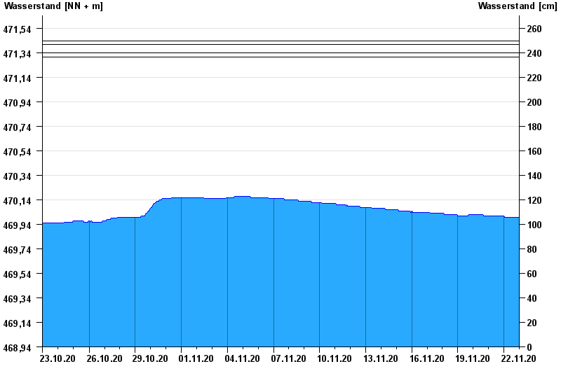
Chart of month Krottenmühl / Simssee
Waterlevel from 23.10.2020 to 22.11.2020
- 01.06.1940 Wasserstand: 471,44 m ü. NN
- 10.07.1954 Wasserstand: 471,41 m ü. NN
- 03.08.1991 Wasserstand: 471,34 m ü. NN
- 11.06.1965 Wasserstand: 471,34 m ü. NN
- 03.06.2013 Wasserstand: 471,31 m ü. NN
Linien: keine | Hauptwerte | Meldestufen | mittlerer Seespiegel | Hochwassermarken | historische Ereignisse
| Date | Waterlevel [m above sealevel] |
|---|---|
| 22.11.2020 23:45 | 470.00 |
| 22.11.2020 23:30 | 470.00 |
| 22.11.2020 23:15 | 470.00 |
| 22.11.2020 23:00 | 470.00 |
| 22.11.2020 22:45 | 470.00 |
| 22.11.2020 22:30 | 470.00 |
| 22.11.2020 22:15 | 470.00 |
© Bayerisches Landesamt für Umwelt 2024