
- Start >
- Lakes >
- Waterlevel >
- Iller - Lech - Bodensee >
- Rottachsee >
- Chart of month

Chart of month Rottachsee / Rottachsee
Waterlevel from 20.12.2021 to 19.01.2022
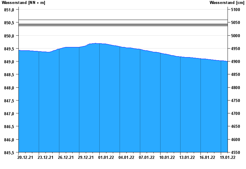
- 02.06.2013 Wasserstand: 850,60 m ü. NN
- 22.07.2007 Wasserstand: 850,44 m ü. NN
- 24.08.2005 Wasserstand: 850,41 m ü. NN
- 06.08.2010 Wasserstand: 850,40 m ü. NN
- 12.08.2002 Wasserstand: 850,36 m ü. NN
Linien: keine | Hauptwerte | Meldestufen | mittlerer Seespiegel | Hochwassermarken | historische Ereignisse
| Date | Waterlevel [m above sealevel] |
|---|---|
| 19.01.2022 23:45 | 849.00 |
| 19.01.2022 23:30 | 849.00 |
| 19.01.2022 23:15 | 849.00 |
| 19.01.2022 23:00 | 849.00 |
| 19.01.2022 22:45 | 849.00 |
| 19.01.2022 22:30 | 849.00 |
| 19.01.2022 22:15 | 849.00 |
© Bayerisches Landesamt für Umwelt 2024