
- Start >
- Lakes >
- Waterlevel >
- Iller - Lech - Bodensee >
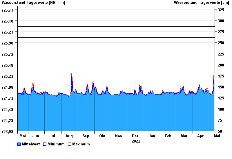
- Bühl >
- Chart of year

Chart of year Bühl / Großer Alpsee
Waterlevel from 12.05.2022 to 11.05.2023
- 22.05.1999 Wasserstand: 726,56 m ü. NN
- 23.08.2005 Wasserstand: 726,35 m ü. NN
- 15.02.1990 Wasserstand: 726,10 m ü. NN
- 02.06.2013 Wasserstand: 726,02 m ü. NN
- 13.03.1981 Wasserstand: 726,00 m ü. NN
Linien: keine | Hauptwerte | Meldestufen | mittlerer Seespiegel | Hochwassermarken | historische Ereignisse
| Date | Mean value [m above sealevel] | Maximum [m above sealevel] | Minimum [m above sealevel] |
|---|---|---|---|
| 11.05.2023 | 725.30 | 725.36 | 725.20 |
| 10.05.2023 | 725.11 | 725.20 | 724.91 |
| 09.05.2023 | 724.87 | 724.91 | 724.85 |
| 08.05.2023 | 724.89 | 724.89 | 724.87 |
| 07.05.2023 | 724.82 | 724.87 | 724.79 |
| 06.05.2023 | 724.80 | 724.81 | 724.79 |
| 05.05.2023 | 724.81 | 724.81 | 724.79 |
© Bayerisches Landesamt für Umwelt 2024