
- Start >
- Lakes >
- Waterlevel >
- Bayern >
- St. Quirin >
- Chart of month

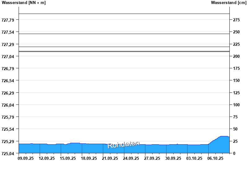
Chart of month St. Quirin / Tegernsee
Waterlevel from 09.09.2025 to 08.10.2025
- 14.09.1899 Wasserstand: 727,91 m ü. NN
- 03.06.2013 Wasserstand: 727,50 m ü. NN
- 10.07.1954 Wasserstand: 727,23 m ü. NN
- 31.05.1940 Wasserstand: 727,14 m ü. NN
- 22.05.1999 Wasserstand: 727,13 m ü. NN
Linien: keine | Hauptwerte | Meldestufen | mittlerer Seespiegel | Hochwassermarken | historische Ereignisse
| Date | Waterlevel [m above sealevel] |
|---|---|
| 09.10.2025 00:45 | 725.37 |
| 09.10.2025 00:30 | 725.37 |
| 09.10.2025 00:15 | 725.38 |
| 09.10.2025 00:00 | 725.38 |
| 08.10.2025 23:45 | 725.38 |
| 08.10.2025 23:30 | 725.38 |
| 08.10.2025 23:15 | 725.38 |
© Bayerisches Landesamt für Umwelt 2025