
- Start >
- Lakes >
- Chemistry >
- Bayern >
- Tiefste Stelle >
- Master data

Master data Tiefste Stelle
Site number: 2110
Community: Tegernsee, St
District: Miesbach
Operator: WWA Rosenheim
Body of water: Tegernsee
Catchment: --
Easting: 704776 (ETRS89 / UTM Zone 32N)
Northing: 5289637
- summary measurement sites
For the measurement site Tiefste Stelle at the moment no extended master data available.
Picture of the measurement site
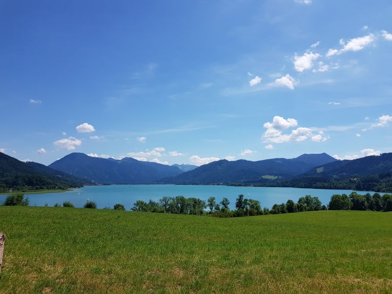
Location of the station Tiefste Stelle / Tegernsee
| Measurement site | Category |
|---|---|
 Sylvensteinsee Gesamtzufluss Sylvensteinsee Gesamtzufluss | Rivers: Runoff |
| Sylvensteinsee Abfluss | Rivers: Runoff |
| Sylvenstein | Rivers: Runoff, Waterlevel |
| Lenggries | Rivers: Runoff, Waterlevel, Water temperature, Water temperature |
| Bad Tölz KW | Rivers: Runoff |
| Walchen | Rivers: Runoff, Waterlevel |
| Sylvenstein | Rivers: Runoff, Waterlevel |
| Peternerbrücke | Rivers: Runoff, Waterlevel |
| Lenggries | Rivers: Runoff, Waterlevel |
| Lenggries Q | Rivers: Runoff |
| Gaißach | Rivers: Runoff, Waterlevel |
| Bad Tölz | Rivers: Runoff, Waterlevel |
| Bairawies | Rivers: Runoff, Waterlevel |
| Valley | Rivers: Runoff, Waterlevel |
| Feldolling | Rivers: Runoff, Waterlevel, Water temperature, Water temperature |
| Oberach | Rivers: Runoff, Waterlevel, Water temperature, Water temperature |
| Bad Kreuth | Rivers: Runoff, Waterlevel |
| Rottach | Rivers: Runoff, Waterlevel |
| Bad Wiessee | Rivers: Runoff, Waterlevel |
| Bad Wiessee | Rivers: Runoff, Waterlevel, Water temperature, Water temperature |
| Miesbach | Rivers: Runoff, Waterlevel, Water temperature, Water temperature |
| Stauden | Rivers: Runoff, Waterlevel, Water temperature, Water temperature |
| Erb | Rivers: Runoff, Waterlevel |
| Au b. Bad Aibling | Rivers: Runoff, Waterlevel, Water temperature, Water temperature |
| Dürrach | Rivers: Waterlevel |
| Schmerold | Rivers: Waterlevel |
| Bad Tölz Brücke | Rivers: Waterlevel |
| Bad Tölz B472 | Rivers: Waterlevel, Water temperature, Water temperature |
| Lenggries | Rivers: Waterlevel |
| Bayerwald | Rivers: Waterlevel |
| Sylvensteinsee Seepegel | Lakes: Waterlevel |
| St. Quirin | Lakes: Waterlevel |
| Schliersee | Lakes: Waterlevel, Water temperature, Water temperature |
| Gmund_Tegernsee | Lakes: Water temperature, Water temperature |
| oh Mdg | Rivers: Chemistry, Biology |
| 200m oh Mdg uh Steg (Chemiemesstelle) | Rivers: Chemistry, Biology |
| 200m oh. Br. Mühltal | Rivers: Chemistry, Biology |
| Mündung Tegernsee | Rivers: Chemistry |
| uh Str. nordwestl Jugendsiedlung Hochland | Rivers: Chemistry, Biology |
| Br. Erb (Pegel) | Rivers: Chemistry |
| Br. Leitzach | Rivers: Chemistry |
| suedlich Greiling; Br oh Mdg | Rivers: Chemistry, Biology |
| Tiefste Stelle | Lakes: Chemistry, Biology |
| Pegel Oberach | Rivers: Chemistry |
| Kiessperre | Rivers: Chemistry |
| oh Sylvensteinspeicher / Pegel | Rivers: Chemistry, Biology |
| Pegel | Rivers: Chemistry, Biology |
| Tiefste Stelle, Südbecken | Lakes: Chemistry, Biology |
| Tiefste Stelle | Lakes: Chemistry, Biology |
| Tiefste Stelle, vor Damm | Lakes: Chemistry, Biology |
| oh Tattenkofer Br | Rivers: Chemistry, Biology |
| bei Rosswies NNW Bad Toelz Fkm196,8 | Rivers: Chemistry, Biology |
| Bruecke oh. Muendung | Rivers: Chemistry |
| Br. uh Enterrottach | Rivers: Chemistry, Biology |
| Br. Festenbach | Rivers: Chemistry, Biology |
| Unt. Br. Marienstein | Rivers: Chemistry, Biology |
| BR OH BAHN AGATHARIED | Rivers: Chemistry |
| uh. Ausleitung, werkkanal bergham | Rivers: Chemistry |
| oh. Straßenbrücke | Rivers: Chemistry, Biology |
| Brücke Straße Haslach-Mattenhofen | Rivers: Chemistry, Biology |
| 01_Ausleitung Tegernsee-Br.Gmund | Rivers: Chemistry |
| oh Mdg in die Isar; oh B13 | Rivers: Chemistry |
| Brücke Pelletsmühle | Rivers: Chemistry |
| Leitzach Achau | Rivers: Chemistry |
| Obergries;Br.Hoehe Sportplatz;Steg uh. Arzbachmündung (Chemiemesstelle) | Rivers: Chemistry |
| Br. Geitau (B307) | Rivers: Chemistry, Biology |
| oberhalb Schullandheim | Rivers: Chemistry, Biology |
| oh. Forsthütte Valepp | Rivers: Chemistry, Biology |
| uh. Brücke Fentbach | Rivers: Chemistry, Biology |
| uh. Brücke Brandstatt | Rivers: Chemistry, Biology |
| 200m oh. Brücke Feldolling | Rivers: Chemistry, Biology |
| Br Obersteinbach | Rivers: Biology |
| westl Untergries; Fkm 204,8 | Rivers: Biology |
| 50m oh Schwarzenbach | Rivers: Biology |
| 250 m oh. Brücke Heufeld-Westerham | Rivers: Biology |
| 800m uh Oberstaudhausen | Rivers: Biology |
| oh. Brücke Drachenthal | Rivers: Biology |
| uh. Mündung Augraben | Rivers: Biology |
| 300m uh. Sägewerk Babenberg | Rivers: Biology |
| uh. Brücke Hölzl | Rivers: Biology |
| Br Torfwerk | Rivers: Biology |
| Transekt 1 nördl. Ostufer, südl. Wasserwacht | Lakes: Biology |
| Transekt 2 Ostufer, südl. Bootshaus | Lakes: Biology |
| Transekt 3 südl. Ostufer uh. B 307 | Lakes: Biology |
| Transekt 4 Südende, Fischhausen | Lakes: Biology |
| Transekt 5 Insel Wörth, Südostufer | Lakes: Biology |
| Transekt 6 Westufer mittig | Lakes: Biology |
| Transekt 7 nördl. Westufer, südl. von Schwimmbad | Lakes: Biology |
| Transekt 8 Gem. Schliersee, ca 50m östl Schiffssteg | Lakes: Biology |
| Transekt 1 | Lakes: Biology |
| Transekt 2 | Lakes: Biology |
| Transekt 3 | Lakes: Biology |
| Transekt 4 | Lakes: Biology |
| Transekt 5 | Lakes: Biology |
| Transekt 6 | Lakes: Biology |
| Transekt 7 | Lakes: Biology |
| Transekt 8 | Lakes: Biology |
| Transekt 9 | Lakes: Biology |
| Transekt 10 | Lakes: Biology |
| Transekt 11 | Lakes: Biology |
| Transekt 12 | Lakes: Biology |
| Transekt 13 | Lakes: Biology |
| Transekt 14 | Lakes: Biology |
| Transekt 1 | Lakes: Biology |
| Transekt 2 | Lakes: Biology |
| Transekt 3 | Lakes: Biology |
| Transekt 4 | Lakes: Biology |
| Transekt 5 | Lakes: Biology |
| Transekt 6 | Lakes: Biology |
| Transekt 1 | Lakes: Biology |
| Transekt 2 | Lakes: Biology |
| Transekt 3 | Lakes: Biology |
| Transekt 5 | Lakes: Biology |
| Transekt 6 | Lakes: Biology |
| Transekt 7 | Lakes: Biology |
| Transekt 8 | Lakes: Biology |
| Transekt 9 | Lakes: Biology |
| Transekt 4 | Lakes: Biology |
| WIECHS R 3 | Groundwater: Upper groundwater layer |
| ARZBACH 246C | Groundwater: Upper groundwater layer |
| Am Gries B2G | Groundwater: Upper groundwater layer |
| Aying Q 10 | Groundwater: Upper groundwater layer |
| LENGGRIES-VORDERR.986 | Groundwater: Upper groundwater layer |
| GERETSRIED 177 | Groundwater: Upper groundwater layer |
| HOLZKIRCHEN | Groundwater: Upper groundwater layer |
| WAITH R 4 | Groundwater: Upper groundwater layer |
| WEIDACH R 20 | Groundwater: Upper groundwater layer |
| BERBLING R 21 | Groundwater: Upper groundwater layer |
| ORTHOFEN R 23 | Groundwater: Upper groundwater layer |
| HOEGLING R 24 | Groundwater: Upper groundwater layer |
| HINRICHSSEGEN R 31 | Groundwater: Upper groundwater layer |
| FELDOLLING R 34 | Groundwater: Upper groundwater layer |
| VAGEN/MANGFALL R 35 | Groundwater: Upper groundwater layer |
| HOEGLING R 41 | Groundwater: Upper groundwater layer |
| OBERADLFURT R 42 | Groundwater: Upper groundwater layer |
| BERBLING R 45 | Groundwater: Upper groundwater layer |
| GOETTING MANGF. 50 | Groundwater: Upper groundwater layer |
| BRUCKMUEHL U.STR. 51 | Groundwater: Upper groundwater layer |
| Kläranlage Feldkirchen Westerham 07 | Groundwater: Upper groundwater layer |
| Pumpstation Feldolling B6G | Groundwater: Upper groundwater layer |
| Am Gries B1G | Groundwater: Upper groundwater layer |
| Am Gries B3G | Groundwater: Upper groundwater layer |
| Am Gries B4G | Groundwater: Upper groundwater layer |
| Am Gries B5G | Groundwater: Upper groundwater layer |
| G3 HRB Feldolling | Groundwater: Upper groundwater layer |
| G6 HRB Feldolling | Groundwater: Upper groundwater layer |
| G10 HRB Feldolling | Groundwater: Upper groundwater layer |
| G12 HRB Feldolling | Groundwater: Upper groundwater layer |
| G17 HRB Feldolling | Groundwater: Upper groundwater layer |
| G18 HRB Feldolling | Groundwater: Upper groundwater layer |
| G19 HRB Feldolling | Groundwater: Upper groundwater layer |
| G23 HRB Feldolling | Groundwater: Upper groundwater layer |
| B1V Vagener Au | Groundwater: Upper groundwater layer |
| B2V Vagener Au | Groundwater: Upper groundwater layer |
| B3V Vagener Au | Groundwater: Upper groundwater layer |
| B6V Vagener Au | Groundwater: Upper groundwater layer |
| Kühzägl, ehem Hausmülldepnie, Deponie 1 | Groundwater: Upper groundwater layer |
| G5 HRB Feldolling | Groundwater: Upper groundwater layer |
| G9 HRB Feldolling | Groundwater: Upper groundwater layer |
| G11 HRB Feldolling | Groundwater: Upper groundwater layer |
| G13 HRB Feldolling | Groundwater: Upper groundwater layer |
| Gw 1 Schwaig | Groundwater: Upper groundwater layer |
| Gw 2 Feldkirchener Straße | Groundwater: Upper groundwater layer |
| Gw 4 Aiblinger Straße | Groundwater: Upper groundwater layer |
| Gw 5 Ahornallee | Groundwater: Upper groundwater layer |
| Gw 6 Schule Feldkirchen | Groundwater: Upper groundwater layer |
| Gw 7 Sportplatz Vagen | Groundwater: Upper groundwater layer |
| Gw 8 Leitzachkraftwerk Ost | Groundwater: Upper groundwater layer |
| Enterrottach 1 | Groundwater: Upper groundwater layer |
| Haslau 2 | Groundwater: Upper groundwater layer |
| Haslau 1 | Groundwater: Upper groundwater layer |
| Kalkofen 1 | Groundwater: Upper groundwater layer |
| Haslau 3 | Groundwater: Upper groundwater layer |
| Kalkofen 3A | Groundwater: Upper groundwater layer |
| Hagrain-Hafelbach 1 | Groundwater: Upper groundwater layer |
| WEIHENLINDEN R 11A | Groundwater: Upper groundwater layer |
| WESTERHAM R 15 | Groundwater: Upper groundwater layer |
| WINKL KLAFFENB. 246A2 | Groundwater: Upper groundwater layer |
| WESTERHAM,SUEDL. R 7 | Groundwater: Upper groundwater layer |
| WALDHEIM R 25 | Groundwater: Upper groundwater layer |
| RIED R 37 | Groundwater: Upper groundwater layer |
| HEUFELD R 38 | Groundwater: Upper groundwater layer |
| HEUFELD R 12 | Groundwater: Upper groundwater layer |
| G27 HRB Feldolling | Groundwater: Upper groundwater layer |
| G30 HRB Feldolling | Groundwater: Upper groundwater layer |
| G31 HRB Feldolling | Groundwater: Upper groundwater layer |
| G28 HRB Feldolling | Groundwater: Upper groundwater layer |
| G29 HRB Feldolling | Groundwater: Upper groundwater layer |
| G25 HRB Feldolling | Groundwater: Upper groundwater layer |
| G24 HRB Feldolling | Groundwater: Upper groundwater layer |
| Hammer Gw2 (BK4) | Groundwater: Upper groundwater layer |
| Hammer Gw1 (BK2) | Groundwater: Upper groundwater layer |
| V2 Vagen | Groundwater: Upper groundwater layer |
| V5 Vagen | Groundwater: Upper groundwater layer |
| V3 Vagen | Groundwater: Upper groundwater layer |
| V1 Vagen | Groundwater: Upper groundwater layer |
| Feldolling P4 | Groundwater: Upper groundwater layer |
| V4 Vagen | Groundwater: Upper groundwater layer |
| Wildbad Kreuth GwM 1 | Groundwater: Upper groundwater layer |
| 4110803500013 | Groundwater: Chemistry |
| 1131813700022 | Groundwater: Chemistry |
| 1131813700032 | Groundwater: Chemistry |
| 4110813600001 | Groundwater: Chemistry |
| 4110823600004 | Groundwater: Chemistry |
| 4110823700067 | Groundwater: Chemistry |
| 4120803700030 | Groundwater: Chemistry |
| 4120833600013 | Groundwater: Chemistry |
| 4120823600020 | Groundwater: Chemistry |
| 4120833700005 | Groundwater: Chemistry |
| 4110823500029 | Groundwater: Chemistry |
| 4120833500032 | Groundwater: Chemistry |
| 1131813500088 | Groundwater: Chemistry |
| 1132833500021 | Groundwater: Chemistry |
| 4120823700027 | Groundwater: Chemistry |
| 4120823500181 | Groundwater: Chemistry |
| 1131803700173 | Groundwater: Chemistry |
| 4120813600039 | Groundwater: Chemistry |
| 1131833300108 | Groundwater: Chemistry |
| 1131823600125 | Groundwater: Chemistry |
| 1132803700229 | Groundwater: Chemistry |
| 4120813700012 | Groundwater: Chemistry |
| 4120803700148 | Groundwater: Chemistry |
| 4120813600101 | Groundwater: Chemistry |
| 4120813500023 | Groundwater: Chemistry |
| Geretsried (Feuerwehrschule) | Meteorology: Precipitation, Snow |
| Aying (Brauerei) | Meteorology: Precipitation, Snow |
| Lenggries (Sylvenstein) | Meteorology: Precipitation, Snow, Wind, Air temperatur, Air moisture, Air pressure, Global radiation |
| Miesbach (Kläranlage) | Meteorology: Precipitation, Snow |
| Achenkirch/Österreich | Meteorology: Precipitation |
| Wettlkam | Meteorology: Precipitation, Wind, Air temperatur, Air moisture, Global radiation |
| Tölz, Bad | Meteorology: Precipitation |
| Kreuth | Meteorology: Precipitation, Snow, Wind, Air temperatur, Air moisture, Air pressure, Global radiation |
| Spitzingsee Freiland 1 | Meteorology: Snow, Air temperatur, Air moisture, Global radiation |
| Bad Tölz (Straßenmeisterei) | Meteorology: Snow |
| Hausham (Straßenmeisterei) | Meteorology: Snow |
| Lenggries - Seekaralm | Meteorology: Snow, Wind, Air temperatur, Air moisture, Air pressure |
| Otterfing | Meteorology: Wind, Air temperatur, Air moisture, Global radiation |
| Brecherspitz | Meteorology: Wind, Air temperatur, Air moisture |
| Geretsried (Klima) | Meteorology: Wind, Air temperatur, Air moisture, Air pressure, Global radiation |
© Bayerisches Landesamt für Umwelt 2026