
- Start >
- Lakes >
- Chemistry >
- Bayern >
- Tiefste Stelle >
- Master data

Master data Tiefste Stelle
Site number: 2054
Community: Klingenbrunner Wald (gemfrei)
District: Freyung-Grafenau
Operator: WWA Deggendorf
Body of water: Rachelsee
Catchment: --
Easting: 822038 (ETRS89 / UTM Zone 32N)
Northing: 5433973
- acid impact measurement sites
For the measurement site Tiefste Stelle at the moment no extended master data available.
Picture of the measurement site
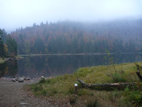
Location of the station Tiefste Stelle / Rachelsee
| Measurement site | Category |
|---|---|
 Zwiesel Zwiesel | Rivers: Runoff, Waterlevel |
| Zwiesel | Rivers: Runoff, Waterlevel, Water temperature, Water temperature |
| Hirschbach | Rivers: Runoff, Waterlevel |
| Lohmannmühle | Rivers: Runoff, Waterlevel |
| Schrottenbaummühle | Rivers: Runoff, Waterlevel |
| Taferlruck | Rivers: Runoff, Waterlevel, Water temperature, Water temperature |
| Schönberg | Rivers: Runoff, Waterlevel |
| Rachel-Diensthütte | Rivers: Runoff, Waterlevel |
| Eberhardsreuth | Rivers: Runoff, Waterlevel |
| Grafenau | Rivers: Runoff, Waterlevel |
| Unterkashof | Rivers: Runoff, Waterlevel |
| Linden | Rivers: Runoff, Waterlevel |
| Röhrnbach | Rivers: Runoff, Waterlevel |
| Trinkwassertalsperre Frauenau | Lakes: Waterlevel |
| Rachelsee | Lakes: Water temperature, Water temperature |
| Stau WK Stadt Zwiesel | Rivers: Chemistry |
| Hoehe Gehmannsberg | Rivers: Chemistry, Biology |
| Tiefste Stelle | Lakes: Chemistry, Biology |
| oh Vorsperre | Rivers: Chemistry, Biology |
| ca. 1068 m | Rivers: Chemistry, Biology |
| oh Vorsperre | Rivers: Chemistry, Biology |
| OH RACHELSEE NOERDLIC | Rivers: Chemistry |
| OH RACHELSEE WESTLICH | Rivers: Chemistry |
| Taferlruck Messstation | Rivers: Chemistry, Biology |
| oh Weidhütte | Rivers: Chemistry, Biology |
| Ludwigsthal-Bhf | Rivers: Chemistry, Biology |
| Tiefste Stelle, Entnahmeturm | Lakes: Chemistry, Biology |
| bei Schauerhof | Rivers: Chemistry, Biology |
| Pegel Grafenau | Rivers: Chemistry, Biology |
| Dimpflmuehle Bruecke | Rivers: Chemistry, Biology |
| noerdl. Sonndorf (Standortuebungsplatz) | Rivers: Chemistry, Biology |
| Pegel Unterkashof | Rivers: Chemistry, Biology |
| Steg suedlich Mitternach | Rivers: Chemistry, Biology |
| u.h. Furthhammer | Rivers: Chemistry |
| Furt suedlich Boehmzwiesel | Rivers: Chemistry, Biology |
| Steg suedlich Scheiben | Rivers: Biology |
| Transekt 1, Nordufer | Lakes: Biology |
| Transekt 2, Nordufer Mitte | Lakes: Biology |
| Transekt 3, Nordufer, 100m westlich Zufluss | Lakes: Biology |
| Transekt 4, Suedufer | Lakes: Biology |
| Transekt 5, Suedufer Mitte, 100m westl. Bach | Lakes: Biology |
| Transekt 6, Suedufer, 15m von Staumauer entfernt | Lakes: Biology |
| Transekt 1 | Lakes: Biology |
| Transekt 2 | Lakes: Biology |
| Transekt 3 | Lakes: Biology |
| Transekt 4 | Lakes: Biology |
| Widderquellen I-III | Groundwater: Flow of well |
| Quellen Keller 1-3 | Groundwater: Flow of well |
| 1131704600032 | Groundwater: Chemistry |
| 1230714500246 | Groundwater: Chemistry |
| 1230724600032 | Groundwater: Chemistry |
| 4110724600001 | Groundwater: Chemistry |
| 4120694500047 | Groundwater: Chemistry |
| 4120714600075 | Groundwater: Chemistry |
| Lindberg-Buchenau | Meteorology: Precipitation, Snow |
| Eging am See-Rohrbachholz | Meteorology: Precipitation, Snow |
| Kirchberg | Meteorology: Precipitation, Wind, Air temperatur, Air moisture, Global radiation |
| Zwiesel (Straßenmeisterei) | Meteorology: Snow |
© Bayerisches Landesamt für Umwelt 2026