
- Start >
- Groundwater >
- Waterlevel of upper layer >
- Regnitz >
- Windsbach HW GWM B2 >
- Chart of total period

Chart of total period Windsbach HW GWM B2
Groundwater levels of the total period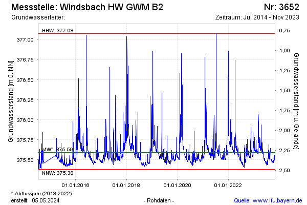
Groundwater level [m above sealevel]: 376.82
Distance to surface [m]: 1.05
Last value from 04.06.2024 13:35
Ground level [m above sealevel]: 377.87
| Date | Groundwater level [m above sealevel] |
|---|---|
| 04.06.2024 | 376.87 |
| 03.06.2024 | 376.83 |
| 02.06.2024 | 376.68 |
| 01.06.2024 | 376.16 |
| 31.05.2024 | 375.69 |
| 30.05.2024 | 375.60 |
| 29.05.2024 | 375.58 |
| 28.05.2024 | 375.59 |
© Bayerisches Landesamt für Umwelt 2024