
- Start >
- Groundwater >
- Waterlevel of upper layer >
- Untere Donau >
- MITTERWÖHR GR.ISAR 70/63 >
- Current data

Current data MITTERWÖHR GR.ISAR 70/63
Groundwater levels of the last 12 months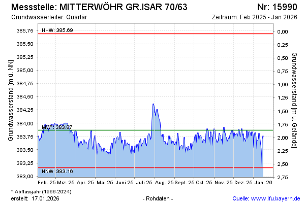
Groundwater level [m above sealevel]: 383.49
Distance to surface [m]: 2.24
Last value from 21.05.2026 10:00
Ground level [m above sealevel]: 385.73
| Date | Groundwater level [m above sealevel] |
|---|---|
| 21.05.2026 | 383.51 |
| 20.05.2026 | 383.58 |
| 19.05.2026 | 383.51 |
| 18.05.2026 | 383.46 |
| 17.05.2026 | 383.66 |
| 16.05.2026 | 383.63 |
| 15.05.2026 | 383.60 |
| 14.05.2026 | 383.55 |
© Bayerisches Landesamt für Umwelt 2026